Category:Dorfkirche Kossenblatt
Jump to navigation
Jump to search
| Object location | | View all coordinates using: OpenStreetMap |
|---|
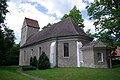
church building in Tauche, Oder-Spree district, Brandenburg state, Germany  .JPG) | |||||
| Upload media | |||||
| Instance of | |||||
|---|---|---|---|---|---|
| Location | Kossenblatt, Tauche (municipality), Oder-Spree District, Brandenburg, Germany | ||||
| Heritage designation | |||||
 | |||||
This is the category of the Brandenburger Baudenkmal (cultural heritage monument) with the ID 09115288 (Wikidata)
|
Media in category "Dorfkirche Kossenblatt"
The following 11 files are in this category, out of 11 total.
-
 Kelch Dönhoff.jpg 2,448 × 3,264; 566 KB
-
 Kelch Dönhoff2.jpg 3,264 × 2,448; 524 KB
-
 Kirche Kossenblatt Tauche.jpg 3,872 × 2,592; 1.65 MB
-
 Kossenblatt 2004 (12).JPG 1,704 × 2,272; 313 KB
-
 Kossenblatt 2004 (13).JPG 1,704 × 2,272; 257 KB
-
 Kossenblatt 2022 (27).JPG 4,896 × 3,264; 3.94 MB
-
 Kossenblatt 2022 (28).JPG 3,264 × 4,896; 6.4 MB
-
 Kossenblatt 2022 (32).JPG 3,264 × 4,896; 6.7 MB
-
 Kossenblatt 2022 (33).JPG 3,264 × 4,896; 6.46 MB
-
 Kossenblatt 2022 (34).JPG 4,896 × 3,264; 4.01 MB
-
 Kossenblatt 2022 (35).JPG 4,896 × 3,264; 6.6 MB


.JPG)
.JPG)
.JPG)
.JPG)
.JPG)
.JPG)
.JPG)