Category:Dorfkirche Kleßen
Jump to navigation
Jump to search
| Object location | | View all coordinates using: OpenStreetMap |
|---|
This is the category of the Brandenburger Baudenkmal (cultural heritage monument) with the ID 09150140 (Wikidata)
|
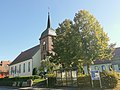
English: Church in Kleßen, Kleßen-Görne municipality, Havelland district, Brandenburg state, Germany.
Deutsch: Dorfkirche in Kleßen, Gemeinde Kleßen-Görne, Landkreis Havelland, Land Brandenburg, Deutschland.
Français : Église de Kleßen, commune de Kleßen-Görne, arrondissement Pays de la Havel, état fédéral de Brandebourg, Allemagne
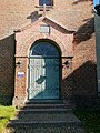
listed hall church in Kleßen in Brandenburg state of Germany  Dorfkirche Kleßen  Haupteingang der Dorfkirche Kleßen | |||||
| Upload media | |||||
| Instance of | |||||
|---|---|---|---|---|---|
| Made from material |
| ||||
| Location | Kleßen, Kleßen-Görne, Havelland District, Brandenburg, Germany | ||||
| Street address |
| ||||
| Architectural style | |||||
| Owned by | |||||
| Occupant | |||||
| Heritage designation | |||||
| Inception |
| ||||
| Date of official opening |
| ||||
| Significant event |
| ||||
| Religion or worldview | |||||
| official website | |||||
 | |||||
Media in category "Dorfkirche Kleßen"
The following 13 files are in this category, out of 13 total.
-
 Dorfkirche Kleßen 20211009 1.jpg 2,736 × 3,648; 4.2 MB
-
 Dorfkirche Kleßen 20211009 10.jpg 2,736 × 3,648; 2.18 MB
-
 Dorfkirche Kleßen 20211009 2.jpg 3,648 × 2,736; 3.15 MB
-
 Dorfkirche Kleßen 20211009 3.jpg 3,648 × 2,736; 3.54 MB
-
 Dorfkirche Kleßen 20211009 4.jpg 2,736 × 3,648; 3.03 MB
-
 Dorfkirche Kleßen 20211009 5.jpg 3,648 × 2,736; 4.06 MB
-
 Dorfkirche Kleßen 20211009 6.jpg 5,120 × 3,840; 6.37 MB
-
 Dorfkirche Kleßen 20211009 7.jpg 3,840 × 5,120; 5.46 MB
-
 Dorfkirche Kleßen 20211009 8.jpg 5,120 × 3,840; 4.49 MB
-
 Dorfkirche Kleßen 20211009 9.jpg 3,648 × 2,736; 2.73 MB
-
 Dorfkirche Kleßen Rückseite.JPG 1,870 × 2,545; 1.18 MB
-
 Dorfkirche Kleßen Turm.JPG 1,778 × 2,583; 857 KB
-
 Kleßen Dorfkirche.JPG 4,693 × 3,791; 3.27 MB


