Category:Dorfkirche Jänschwalde
Jump to navigation
Jump to search
| Object location | | View all coordinates using: OpenStreetMap |
|---|
church building in Brandenburg state, Germany  | |||||
| Upload media | |||||
| Instance of | |||||
|---|---|---|---|---|---|
| Location | Jänschwalde, Spree-Neiße District, Brandenburg, Germany | ||||
| Street address |
| ||||
| Architectural style | |||||
| Heritage designation | |||||
| Inception |
| ||||
 | |||||
This is the category of the Brandenburger Baudenkmal (cultural heritage monument) with the ID 09125191 (Wikidata)
|
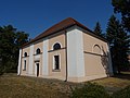
English: Pictures of the church in Jänschwalde, Jänschwalde municipality, Spree-Neiße district, Brandenburg state, Germany.
Deutsch: Ansichten der Kirche in Jänschwalde, Gemeinde Jänschwalde, Landkreis Spree-Neiße, Land Brandenburg, Deutschland.
Français : Photos de l'église à Jänschwalde, commune de Jänschwalde, arrondissement de Spree-Neiße, état fédéral de Brandebourg, Allemagne
Español: Vistas de la iglesia en Jänschwalde, municipio de Jänschwalde, distrito de Spree-Neiße, estado federado de Brandeburgo, Alemania
Address: Kirchstraße 10, 03197 Jänschwalde
Media in category "Dorfkirche Jänschwalde"
This category contains only the following file.
-
 JänschwaldeKirche.jpg 2,484 × 1,867; 2.1 MB