Category:Dorfkirche Hohenfinow
Jump to navigation
Jump to search
| Object location | | View all coordinates using: OpenStreetMap |
|---|
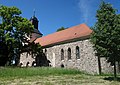
church building in Brandenburg state, Germany   | |||||
| Upload media | |||||
| Instance of | |||||
|---|---|---|---|---|---|
| Location | Hohenfinow, Barnim District, Brandenburg, Germany | ||||
| Heritage designation | |||||
 | |||||
This is the category of the Brandenburger Baudenkmal (cultural heritage monument) with the ID 09175237 (Wikidata)
|
Deutsch: Ansichten der Kirche in Hohenfinow, Gemeinde Hohenfinow, Landkreis Barnim, Land Brandenburg, Deutschland.
English: Pictures of the church in Hohenfinow, Hohenfinow municipality, Barnim district, Brandenburg state, Germany.
Français : Photos de l'église à Hohenfinow, commune de Hohenfinow, arrondissement de Barnim, état fédéral de Brandebourg, Allemagne
Español: Vistas de la iglesia en Hohenfinow, municipio de Hohenfinow, distrito de Barnim, estado federado de Brandeburgo, Alemania
Pages in category "Dorfkirche Hohenfinow"
This category contains only the following page.
Media in category "Dorfkirche Hohenfinow"
The following 20 files are in this category, out of 20 total.
-
 2023-12-31 Kirche-Hohemfinow.jpg 1,400 × 894; 351 KB
-
 Dorfkirche Hohenfinow 2018 NW.jpg 3,648 × 4,864; 8.76 MB
-
 Dorfkirche Hohenfinow 2018 SE.jpg 4,515 × 3,180; 6.93 MB
-
 Dorfkirche Hohenfinow 2018 Turmhaube.jpg 3,648 × 4,864; 4.96 MB
-
 Dorfkirche Hohenfinow 2018 Westportal.jpg 3,648 × 4,864; 6.86 MB
-
 Hohenfinow Kirche 01.jpg 4,512 × 3,191; 2.85 MB
-
 Hohenfinow Kirche 02.jpg 2,736 × 3,320; 2.84 MB
-
 Hohenfinow Kirche 03.jpg 4,000 × 3,149; 2.75 MB
-
 Hohenfinow Kirche 04.jpg 3,648 × 2,736; 2 MB
-
 Hohenfinow Kirche 05.jpg 4,344 × 3,032; 2.82 MB
-
 Hohenfinow Kirche 06.jpg 5,742 × 3,000; 3.7 MB
-
 Hohenfinow Kirche 07.jpg 3,728 × 2,798; 2.5 MB
-
 Hohenfinow Kirche 08.jpg 3,648 × 2,736; 2.03 MB
-
 Hohenfinow Kirche 09.jpg 3,648 × 2,600; 1.77 MB
-
 Hohenfinow Kirche 10.jpg 3,648 × 1,873; 2.06 MB
-
 Hohenfinow Kirche 11.jpg 2,736 × 3,160; 1.79 MB
-
 Hohenfinow Kirche 12.jpg 3,648 × 2,736; 2.22 MB
-
 Hohenfinow Kirche 13.jpg 2,664 × 1,784; 1.16 MB
-
 Hohenfinow Kirche 14.jpg 3,648 × 2,736; 2.2 MB
-
 Kirche-hohenfinow-rr.jpg 800 × 577; 98 KB


