Category:Dorfkirche Heinersdorf (Steinhöfel)
Jump to navigation
Jump to search
| Object location | | View all coordinates using: OpenStreetMap |
|---|
church building in Oder-Spree district, Brandenburg state, Germany  | |||||
| Upload media | |||||
| Instance of | |||||
|---|---|---|---|---|---|
| Location | Heinersdorf, Steinhöfel, Oder-Spree District, Brandenburg, Germany | ||||
| Street address |
| ||||
| Heritage designation | |||||
 | |||||
This is the category of the Brandenburger Baudenkmal (cultural heritage monument) with the ID 09115124 (Wikidata)
|
Media in category "Dorfkirche Heinersdorf (Steinhöfel)"
The following 7 files are in this category, out of 7 total.
-
 Heinersdorf - Dorfkirche - panoramio.jpg 480 × 640; 77 KB
-
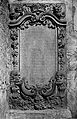
 Heinersdorf Grabstein für Amtmann B. Tile Lebus Tafel 18.jpg 4,194 × 6,271; 16.35 MB
-
 Heinersdorf Grabstein für Amtmann B. Tile.jpg 2,996 × 4,649; 8.44 MB
-
 Heinersdorf Kelch Lebus Tafel 19.jpg 4,194 × 6,271; 15.89 MB
-
 Heinersdorf Kelch.jpg 2,873 × 4,511; 5.32 MB
-
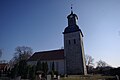 Kirche Heinersdorf Nord Steinhöfel.jpg 3,872 × 2,592; 3.18 MB
-
 Kirche Heinersdorf Steinhöfel.jpg 2,592 × 3,872; 6.68 MB


