Category:Dorfkirche Großziethen
Jump to navigation
Jump to search
| Object location | | View all coordinates using: OpenStreetMap |
|---|
church building in Brandenburg state, Germany  | |||||
| Upload media | |||||
| Instance of | |||||
|---|---|---|---|---|---|
| Made from material | |||||
| Location | Großziethen, Schönefeld, Dahme-Spreewald District, Brandenburg, Germany | ||||
| Architectural style | |||||
| Heritage designation | |||||
| Inception |
| ||||
 | |||||
This is the category of the Brandenburger Baudenkmal (cultural heritage monument) with the ID 09140122 (Wikidata)
|
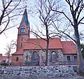
Deutsch: Ansichten der Kirche in Großziethen, Gemeinde Schönefeld, Landkreis Dahme-Spreewald, Land Brandenburg, Deutschland.
English: Pictures of the church in Großziethen, Schönefeld municipality, Dahme-Spreewald district, Brandenburg state, Germany
Français : Photos de l'église à Großziethen, commune de Schönefeld, arrondissement de Dahme-Spreewald, état fédéral de Brandebourg, Allemagne
Media in category "Dorfkirche Großziethen"
The following 8 files are in this category, out of 8 total.
-
 Dorfkirche Großziethen 2018 E.jpg 3,596 × 4,826; 6.61 MB
-
 Dorfkirche Großziethen 2018 N.jpg 4,798 × 3,558; 6.25 MB
-
 Dorfkirche Großziethen 2018 NE.jpg 4,864 × 3,648; 7.73 MB
-
 Dorfkirche Großziethen 2018 NW.jpg 3,648 × 4,864; 6.23 MB
-
 Dorfkirche Großziethen 2018 S.jpg 5,043 × 4,746; 11.06 MB
-
 Dorfkirche Großziethen 2018 W.jpg 3,648 × 4,864; 7.87 MB
-
 Dorfkirche Großziethen 2018 Westportal.jpg 3,538 × 4,784; 5.37 MB
-
 Großziethen Dorfkirche.jpg 3,088 × 2,304; 1.6 MB


