Category:Dorfkirche Groß Oßnig
Jump to navigation
Jump to search
| Object location | | View all coordinates using: OpenStreetMap |
|---|
church building in Brandenburg state, Germany  | |||||
| Upload media | |||||
| Instance of | |||||
|---|---|---|---|---|---|
| Location | Groß Oßnig, Neuhausen/Spree, Spree-Neiße District, Brandenburg, Germany | ||||
| Street address |
| ||||
| Heritage designation | |||||
| Inception |
| ||||
 | |||||
This is the category of the Brandenburger Baudenkmal (cultural heritage monument) with the ID 09125452 (Wikidata)
|
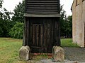
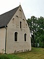
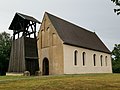
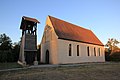
English: Pictures of the church in Groß Oßnig, Neuhausen/Spree municipality, Spree-Neiße district, Brandenburg state, Germany.
Deutsch: Ansichten der Kirche in Groß Oßnig, Gemeinde Neuhausen/Spree, Landkreis Spree-Neiße, Land Brandenburg, Deutschland.
Français : Photos de l'église à Groß Oßnig, commune de Neuhausen/Spree, arrondissement de Spree-Neiße, état fédéral de Brandebourg, Allemagne
Español: Vistas de la iglesia en Groß Oßnig, municipio de Neuhausen/Spree, distrito de Spree-Neiße, estado federado de Brandeburgo, Alemania
Address: Oßniger Dorfstraße 3, Groß Oßnig, 03058 Neuhausen/Spree
Media in category "Dorfkirche Groß Oßnig"
The following 13 files are in this category, out of 13 total.
-
 Ensemble Kirche kriegerdenkmal groß oßnig 2020-08-22 11.jpg 3,648 × 2,736; 3.59 MB
-
 Ensemble Kirche kriegerdenkmal groß oßnig 2020-08-22 12.jpg 2,736 × 3,648; 2.97 MB
-
 Ensemble Kirche kriegerdenkmal groß oßnig 2020-08-22 13.jpg 3,648 × 2,736; 2.67 MB
-
 Ensemble Kirche kriegerdenkmal groß oßnig 2020-08-22 2.jpg 3,648 × 2,736; 3.03 MB
-
 Ensemble Kirche kriegerdenkmal groß oßnig 2020-08-22 3.jpg 2,736 × 3,648; 1.79 MB
-
 Ensemble Kirche kriegerdenkmal groß oßnig 2020-08-22 4.jpg 3,648 × 2,736; 2.55 MB
-
 Ensemble Kirche kriegerdenkmal groß oßnig 2020-08-22 5.jpg 3,648 × 2,736; 2.36 MB
-
 Ensemble Kirche kriegerdenkmal groß oßnig 2020-08-22 6.jpg 3,648 × 2,736; 2.54 MB
-
 Ensemble Kirche kriegerdenkmal groß oßnig 2020-08-22 8.jpg 3,648 × 2,736; 2.48 MB
-
 Groß Oßnig, Dorfstraße.png 2,567 × 1,680; 5.56 MB
-
 GroßOsnigKircheTurmKriegerdenkmal.jpg 3,346 × 2,502; 4.09 MB
-
 Wjeliki Wóseńk – cyrkej.jpg 3,800 × 2,533; 5 MB
-
 Wjeliki Wóseńk – wojerski pomnik.jpg 3,800 × 2,533; 5.67 MB


