Category:Dorfkirche Gräningen
Jump to navigation
Jump to search
| Object location | | View all coordinates using: OpenStreetMap |
|---|
church building in Brandenburg state, Germany   | |||||
| Upload media | |||||
| Instance of | |||||
|---|---|---|---|---|---|
| Location | Gräningen, Nennhausen, Havelland District, Brandenburg, Germany | ||||
| Heritage designation | |||||
 | |||||
This is the category of the Brandenburger Baudenkmal (cultural heritage monument) with the ID 09150092 (Wikidata)
|
English: Pictures of the church in Gräningen, Nennhausen municipality, Havelland district, Brandenburg state, Germany.
Deutsch: Ansichten der Kirche in Gräningen, Gemeinde Nennhausen, Landkreis Havelland, Land Brandenburg, Deutschland.
Français : Photos de l'église à Gräningen, commune de Nennhausen, arrondissement de Havelland, état fédéral de Brandebourg, Allemagne
Español: Vistas de la iglesia en Gräningen, municipio de Nennhausen, distrito de Havelland, estado federado de Brandeburgo, Alemania
Address:
Nennhausener Straße 10, Gräningen, 14715 Nennhausen
Subcategories
This category has only the following subcategory.
I
Pages in category "Dorfkirche Gräningen"
This category contains only the following page.
Media in category "Dorfkirche Gräningen"
The following 15 files are in this category, out of 15 total.
-
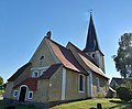
 Gräningen church 2016 E.jpg 3,574 × 4,810; 5.29 MB
-
 Gräningen church 2016 NE.jpg 5,806 × 4,802; 7.69 MB
-
 Gräningen church 2016 portal SW.jpg 3,648 × 4,864; 5.65 MB
-
 Gräningen church 2016 S.jpg 4,864 × 3,648; 5.73 MB
-
 Gräningen church 2016 SE.jpg 4,228 × 4,104; 5.82 MB
-
 Gräningen church 2016 SW.jpg 4,536 × 4,766; 6.98 MB
-
 Gräningen church 2016 tower N.jpg 3,597 × 6,030; 7.06 MB
-
 2017-11-18 - Gräningen Kirche.jpg 3,264 × 2,448; 1.7 MB
-
 2019-03-22 - Gräningen Kirche.jpg 3,264 × 2,448; 2.28 MB
-
 Dorfkirche Gräningen 2022 S.jpg 3,598 × 4,826; 5.48 MB
-
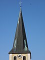 Dorfkirche Gräningen 2022 Turmhelm.jpg 3,648 × 4,864; 3.52 MB
-
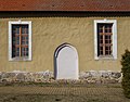 Dorfkirche Gräningen 2022 vermauertes Südportal.jpg 3,933 × 3,075; 4.18 MB
-
 Dorfkirche Gräningen 2022 Fenster.jpg 3,624 × 4,844; 5.45 MB
-
 Dorfkirche Gräningen 2022 Südwestportal.jpg 3,636 × 4,854; 5.9 MB
-
 Gräningen Kirche.png 492 × 656; 351 KB


