
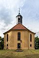
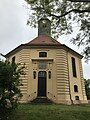
Category:Dorfkirche Golzow (Mittelmark)
| Object location | | View all coordinates using: OpenStreetMap |
|---|
church building in Potsdam-Mittelmark district, Brandenburg state, Germany  | |||||
| Upload media | |||||
| Instance of | |||||
|---|---|---|---|---|---|
| Location | Golzow, Potsdam-Mittelmark District, Brandenburg, Germany | ||||
| Street address |
| ||||
| Architectural style | |||||
| Heritage designation | |||||
| Inception |
| ||||
| Religion or worldview | |||||
 | |||||
This is the category of the Brandenburger Baudenkmal (cultural heritage monument) with the ID 09190190 (Wikidata)
|
Media in category "Dorfkirche Golzow (Mittelmark)"
The following 21 files are in this category, out of 21 total.
-
 Church of Golzow, Brandenburg, Germany - panoramio.jpg 1,600 × 1,200; 410 KB
-
 Dorfkirche Golzow (32550359532).jpg 3,456 × 5,184; 6.76 MB
-
 Dorfkirche Golzow 01 Gedenkstein.jpg 3,228 × 4,304; 12.79 MB
-
 Dorfkirche Golzow 02 erste urkundl. Erwaehnung.jpg 3,336 × 4,448; 12.69 MB
-
 Dorfkirche Golzow 03 alter Kirchfriedhof.jpg 3,294 × 4,392; 15.99 MB
-
 Dorfkirche Golzow 20160712 1.jpg 5,184 × 3,456; 10.45 MB
-
 Dorfkirche Golzow 20160712 2.jpg 5,137 × 3,425; 7.37 MB
-
 Dorfkirche Golzow 20160712 3.jpg 3,039 × 4,558; 4.6 MB
-
 Dorfkirche Golzow 20160712 4.jpg 3,456 × 5,184; 5.72 MB
-
 Dorfkirche Golzow 20160712 5.jpg 2,943 × 4,415; 3.79 MB
-
 Dorfkirche Golzow 20160712 6.jpg 3,295 × 4,942; 4.15 MB
-
 Dorfkirche Golzow 20160712 7.jpg 3,456 × 5,184; 7.01 MB
-
 Dorfkirche Golzow 20160712 8.jpg 5,184 × 3,456; 9.39 MB
-
 Dorfkirche Golzow 2019-03-15 -1.jpg 4,896 × 3,672; 4.65 MB
-
 Dorfkirche Golzow 2019-03-15 -2.jpg 4,896 × 3,672; 6.41 MB
-
 Dorfkirche Golzow Nordansicht.jpg 4,032 × 3,024; 3.13 MB
-
 Dorfkirche Golzow Ostansicht.jpg 3,024 × 4,032; 2.24 MB
-
 Dorfkirche Golzow Südansicht.jpg 3,024 × 4,032; 2.19 MB
-
 Dorfkirche Golzow Westansicht.jpg 3,024 × 4,032; 3.48 MB
-
 Dorfkirche Golzow Westportal.jpg 3,024 × 4,032; 2.18 MB
-
 Golzow Kirche.jpg 960 × 1,280; 297 KB

.jpg)


