Category:Dorfkirche Glienicke/Nordbahn
Jump to navigation
Jump to search
| Object location | | View all coordinates using: OpenStreetMap |
|---|
church building in Oberhavel district, Brandenburg state, Germany .jpg) | |||||
| Upload media | |||||
| Instance of | |||||
|---|---|---|---|---|---|
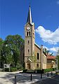
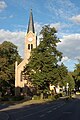
| Location | Glienicke/Nordbahn, Oberhavel District, Brandenburg, Germany | ||||
| Street address |
| ||||
| Architectural style | |||||
| Architect | |||||
| Heritage designation | |||||
| Inception |
| ||||
| Width |
| ||||
| Length |
| ||||
| Area |
| ||||
 | |||||
English: Pictures of the church in Glienicke/Nordbahn, Glienicke/Nordbahn municipality, Oberhavel district, Brandenburg state, Germany.
Deutsch: Ansichten der Kirche in Glienicke/Nordbahn, Gemeinde Glienicke/Nordbahn , Landkreis Oberhavel , Land Brandenburg , Deutschland.
Français : Photos de l'église à Glienicke/Nordbahn, commune de Glienicke/Nordbahn, , arrondissement de Oberhavel , état federé de Brandebourg , Allemagne.
Español: Vistas de la iglesia en Glienicke/Nordbahn, municipio de Glienicke/Nordbahn, distrito de Oberhavel , estado federado de Brandeburgo , Alemania.
This is the category of the Brandenburger Baudenkmal (cultural heritage monument) with the ID 09165345 (Wikidata)
|
Address: Hauptstraße 71, 16548 Glienicke/Nordbahn
Subcategories
This category has only the following subcategory.
Media in category "Dorfkirche Glienicke/Nordbahn"
The following 9 files are in this category, out of 9 total.
-
 Dorfkirche Glienicke-Nordbahn 2014 WSW.jpg 2,894 × 2,170; 1.01 MB
-
 Dorfkirche Glienicke-Nordbahn 2022 Fenster.jpg 1,246 × 2,216; 591 KB
-
 Ev. Kirche Glienicke (Nordbahn) bei Nacht.png 1,726 × 1,726; 3.37 MB
-
 Evangelische Dorfkirche Glienicke (Nordbahn) Eingang.png 1,812 × 2,415; 8.42 MB
-
 Evangelische Dorfkirche Glienicke (Nordbahn) Gedenktafel »1989«.png 1,902 × 2,536; 9.55 MB
-
 Evangelische Dorfkirche Glienicke (Nordbahn).jpg 3,307 × 4,677; 2.79 MB
-
 Glienicke-Nordbahn church 2010 W.jpg 2,000 × 3,008; 2.58 MB
-
 Glienicke-Nordbahn church 2012 SE.jpg 1,812 × 1,984; 1.51 MB
-
 Peter-siegele 2017 orgel-dorfkirche-glienicke.jpg 3,800 × 2,850; 1.09 MB


_bei_Nacht.png)
_Eingang.png)
_Gedenktafel_%C2%BB1989%C2%AB.png)


