
Category:Dorfkirche Germendorf
| Object location | | View all coordinates using: OpenStreetMap |
|---|
This is the category of the Brandenburger Baudenkmal (cultural heritage monument) with the ID 09165002 (Wikidata)
|
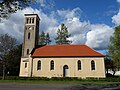
Deutsch: Dorfkirche in Germendorf, Stadt Oranienburg, Landkreis Oberhavel, Land Brandenburg, Deutschland
Français : Église de Germendorf, ville d'Oranienburg, arrondissement Haute-Havel, état fédéral de Brandebourg, Allemagne
church building in Oberhavel district, Brandenburg state, Germany  | |||||
| Upload media | |||||
| Instance of | |||||
|---|---|---|---|---|---|
| Location | Germendorf, Oranienburg, Oberhavel District, Brandenburg, Germany | ||||
| Heritage designation | |||||
 | |||||
Media in category "Dorfkirche Germendorf"
The following 10 files are in this category, out of 10 total.
-
 Dorfkirche Germendorf 2017 ESE.jpg 3,648 × 4,864; 6.85 MB
-
 Dorfkirche Germendorf 2017 NE.jpg 5,552 × 4,589; 11.72 MB
-
 Dorfkirche Germendorf 2017 NW.jpg 4,864 × 3,648; 7.27 MB
-
 Dorfkirche Germendorf 2017 S.jpg 4,864 × 3,648; 5.7 MB
-
 Dorfkirche Germendorf 2017 SE.jpg 4,790 × 3,548; 7.2 MB
-
 Dorfkirche Germendorf 2017 SW.jpg 4,744 × 3,482; 6.06 MB
-
 Dorfkirche Germendorf 2017 Westportal.jpg 3,648 × 4,864; 4.67 MB
-
 Friedenseiche und Dorfkirche Germendorf 2017 SW.jpg 5,125 × 4,411; 9.82 MB
-
 Kirche Germendorf.jpg 600 × 800; 158 KB
-
 Oranienburg Germendorf Kirche 2018-05-12 160743 CEST.jpg 3,816 × 3,816; 6.31 MB


