Category:Dorfkirche Gantikow
Jump to navigation
Jump to search
| Object location | | View all coordinates using: OpenStreetMap |
|---|
 | |||||
| Upload media | |||||
| Instance of | |||||
|---|---|---|---|---|---|
| Location | Gantikow, Kyritz, Ostprignitz-Ruppin District, Brandenburg, Germany | ||||
| Heritage designation | |||||
 | |||||
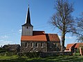
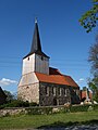
This is the category of the Brandenburger Baudenkmal (cultural heritage monument) with the ID 09170541 (Wikidata)
|
English: Church in Gantikow, Kyritz municipality, Ostprignitz-Ruppin district, Brandenburg state, Germany
Deutsch: Dorfkirche Gantikow, Stadt Kyritz, Landkreis Ostprignitz-Ruppin, Land Brandenburg, Deutschland.
Français : Église de Gantikow, ville de Kyritz, arrondissement Prignitz-de-l'Est-Ruppin, état fédéral de Brandebourg, Allemagne
Media in category "Dorfkirche Gantikow"
The following 6 files are in this category, out of 6 total.
-
 Gantikow church 2016 N.JPG 4,864 × 3,648; 4.67 MB
-
 Gantikow church 2016 NW.JPG 3,648 × 4,864; 4.71 MB
-
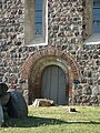 Gantikow church 2016 portal S.JPG 3,648 × 4,864; 7.36 MB
-
 Gantikow church 2016 S.JPG 4,864 × 3,648; 6.31 MB
-
 Gantikow church 2016 SE.JPG 3,648 × 4,864; 7.3 MB
-
 Gantikow church 2016 SW.JPG 3,648 × 4,864; 5.88 MB


