Category:Dorfkirche Gahro
Jump to navigation
Jump to search
| Object location | | View all coordinates using: OpenStreetMap |
|---|
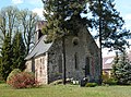
church building in Brandenburg state, Germany _Feldsteinkirche.jpg) | |||||
| Upload media | |||||
| Instance of | |||||
|---|---|---|---|---|---|
| Dedicated to | |||||
| Location | Gahro, Crinitz, Elbe-Elster District, Brandenburg, Germany | ||||
| Street address |
| ||||
| Heritage designation | |||||
| Religion or worldview | |||||
 | |||||
This is the category of the Brandenburger Baudenkmal (cultural heritage monument) with the ID 09135117 (Wikidata)
|
Media in category "Dorfkirche Gahro"
The following 6 files are in this category, out of 6 total.
-
 20150429200DR Gahro (Crinitz) Feldsteinkirche.jpg 2,508 × 1,836; 3.46 MB
-
 20150429205DR Gahro (Crinitz) Feldsteinkirche.jpg 2,481 × 1,830; 3.89 MB
-
 20150429210MDR Gahro (Crinitz) Feldsteinkirche.jpg 2,436 × 2,006; 3.88 MB
-
 20150429215DR Gahro (Crinitz) Feldsteinkirche.jpg 2,400 × 1,916; 3.16 MB
-
 20150429220DR Gahro (Crinitz) Feldsteinkirche.jpg 2,430 × 1,899; 3.86 MB
-
 GahroKirche.jpg 3,364 × 2,539; 4.68 MB
_Feldsteinkirche.jpg)
_Feldsteinkirche.jpg)
_Feldsteinkirche.jpg)
_Feldsteinkirche.jpg)
