Category:Dorfkirche Fichtenberg (Mühlberg/Elbe)
Jump to navigation
Jump to search
| Object location | | View all coordinates using: OpenStreetMap |
|---|
church building in Fichtenberg/Elbe, Germany  | |||||
| Upload media | |||||
| Instance of | |||||
|---|---|---|---|---|---|
| Location | Fichtenberg/Elbe, Mühlberg/Elbe, Elbe-Elster District, Brandenburg, Germany | ||||
| Street address |
| ||||
| Heritage designation | |||||
| Inception |
| ||||
| Width |
| ||||
| Length |
| ||||
| Religion or worldview | |||||
 | |||||
This is the category of the Brandenburger Baudenkmal (cultural heritage monument) with the ID 09135390 (Wikidata)
|
Media in category "Dorfkirche Fichtenberg (Mühlberg/Elbe)"
The following 16 files are in this category, out of 16 total.
-
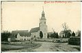 00948-Fichtenberg-Elbe-1899-Kirche-Brück & Sohn Kunstverlag.jpg 1,548 × 1,000; 437 KB
-
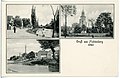
 05447-Fichtenberg-1904-Schloßstraße-Brück & Sohn Kunstverlag.jpg 1,523 × 1,000; 581 KB
-
 20366-Fichtenberg-1917-Blick auf Fichtenberg-Brück & Sohn Kunstverlag.jpg 1,533 × 1,000; 469 KB
-
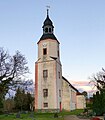 Fichtenberg Dorfkirche Mühlberg 2017 P1110208.jpg 2,105 × 2,414; 729 KB
-
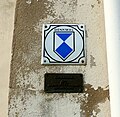 Fichtenberg Dorfkirche Mühlberg Denkmalzeichen Okt 2017 P1110238.jpg 1,829 × 1,785; 766 KB
-
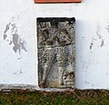 Fichtenberg Dorfkirche Mühlberg Epitaph Südseite Okt 2017 P1110236.jpg 1,958 × 1,886; 687 KB
-
 Fichtenberg Dorfkirche Mühlberg Friedhof P1110240.jpg 4,318 × 3,364; 1.37 MB
-
 Fichtenberg Dorfkirche Mühlberg Friedhofstor Okt 2017 P1110231.jpg 3,252 × 1,841; 1.25 MB
-
 Fichtenberg Dorfkirche Mühlberg Grabmal P1110211.jpg 2,937 × 4,001; 1.89 MB
-
 Fichtenberg Dorfkirche Mühlberg Ostansicht Okt 2017 P1110223.jpg 4,608 × 3,456; 2.53 MB
-
 Fichtenberg Dorfkirche Mühlberg Patronatsloge Okt 2017 P1110227.jpg 2,190 × 1,777; 292 KB
-
 Fichtenberg Dorfkirche Mühlberg Pforte Südseite Okt 2017 P1110237.jpg 1,632 × 1,958; 688 KB
-
 Fichtenberg Dorfkirche Mühlberg Pforte Turm P1110239.jpg 3,815 × 2,956; 913 KB
-
 Fichtenberg Dorfkirche Mühlberg Trauerhalle P1110219.jpg 3,379 × 2,455; 1.68 MB
-
 Fichtenberg Dorfkirche Mühlberg Turm Okt 2017 P1110224.jpg 3,156 × 4,510; 1.02 MB
-
 Kirche Fichtenberg P1110208 b.jpg 2,018 × 2,363; 601 KB


