Category:Dorfkirche Dierberg
Jump to navigation
Jump to search
| Object location | | View all coordinates using: OpenStreetMap |
|---|
church building in Brandenburg  | |||||
| Upload media | |||||
| Instance of | |||||
|---|---|---|---|---|---|
| Location | Dierberg, Rheinsberg, Ostprignitz-Ruppin District, Brandenburg, Germany | ||||
| Heritage designation | |||||
 | |||||
This is the category of the Brandenburger Baudenkmal (cultural heritage monument) with the ID 09170251 (Wikidata)
|
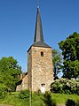
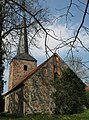
English: Dierberg church, Rheinsberg municipality, Ostprignitz-Ruppin district, Brandenburg state, Germany
Deutsch: Dorfkirche in Dierberg, Stadt Rheinsberg, Landkreis Ostprignitz-Ruppin, Land Brandenburg, Deutschland
Français : Église de Dierberg, ville de Rheinsberg, arrondissement Prignitz-de-l'Est-Ruppin, état fédéral de Brandebourg, Allemagne
Media in category "Dorfkirche Dierberg"
The following 4 files are in this category, out of 4 total.
-
 Dierberg church W 2015.JPG 1,383 × 1,871; 1.24 MB
-
 Dierberg church.jpg 2,238 × 3,030; 1.14 MB
-
 Dierberg Kirche.jpg 3,792 × 5,056; 8.3 MB
-
 Orgel Dorfkirche Dierberg.jpg 2,000 × 2,992; 1.83 MB


