Category:Dorfkirche Chorin
Jump to navigation
Jump to search
| Object location | | View all coordinates using: OpenStreetMap |
|---|
church building in Brandenburg state, Germany  | |||||
| Upload media | |||||
| Instance of | |||||
|---|---|---|---|---|---|
| Location | Chorin, Barnim District, Brandenburg, Germany | ||||
| Street address |
| ||||
| Heritage designation | |||||
| Inception |
| ||||
| Width |
| ||||
| Length |
| ||||
| Area |
| ||||
| Religion or worldview | |||||
 | |||||
This is the category of the Brandenburger Baudenkmal (cultural heritage monument) with the ID 09175144 (Wikidata)
|
Summary
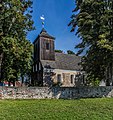
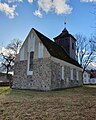
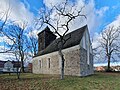
[edit]Deutsch: Dorfkirche Chorin, Landkreis Barnim, Land Brandenburg, Deutschland
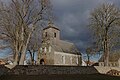
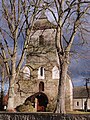
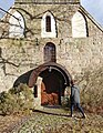
English: Chorin village church, Barnim district, Brandenburg state, Germany
Deutsch: Weitere Kirchen finden sich unter: Liste der Kirchengebäude im Landkreis Barnim
English: More churches can be found under: Complete list of churches in Barnim district (German)
Subcategories
This category has only the following subcategory.
I
- Interior of Dorfkirche Chorin (12 F)
Pages in category "Dorfkirche Chorin"
This category contains only the following page.
Media in category "Dorfkirche Chorin"
The following 13 files are in this category, out of 13 total.
-
 Chorin Dorfkirche 511.jpg 3,264 × 4,896; 11.25 MB
-
 Chorin Dorfkirche 512.jpg 3,264 × 4,896; 12.52 MB
-
 Chorin Dorfkirche 513.jpg 3,264 × 4,896; 14.61 MB
-
 ChorinKirche.jpg 2,000 × 2,125; 1.56 MB
-
 Dorfkirche Chorin 2023 Fenster.jpg 2,731 × 3,642; 1.94 MB
-
 Dorfkirche Chorin 2023 N.jpg 4,032 × 3,024; 4.16 MB
-
 Dorfkirche Chorin 2023 NE.jpg 2,872 × 3,603; 1.94 MB
-
 Dorfkirche Chorin 2023 SE.jpg 3,456 × 2,592; 2.23 MB
-
 Dorfkirche Chorin 2023 SW.jpg 4,032 × 2,688; 3.45 MB
-
 Dorfkirche Chorin 2023 Turm.jpg 3,024 × 3,929; 2.91 MB
-
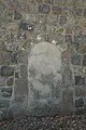
 Dorfkirche Chorin 2023 vermauertes Nordportal.jpg 4,032 × 3,024; 5.62 MB
-
 Dorfkirche Chorin 2023 W.jpg 2,880 × 3,840; 3.84 MB
-
 Dorfkirche Chorin 2023 Westportal.jpg 3,024 × 3,906; 4.09 MB


