Category:Dorfkirche Bendelin
Jump to navigation
Jump to search
| Object location | | View all coordinates using: OpenStreetMap |
|---|
This is the category of the Brandenburger Baudenkmal (cultural heritage monument) with the ID 09160036 (Wikidata)
|
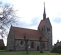
church building in Brandenburg state, Germany  | |||||
| Upload media | |||||
| Instance of | |||||
|---|---|---|---|---|---|
| Location | Bendelin, Plattenburg, Prignitz District, Brandenburg, Germany | ||||
| Heritage designation | |||||
 | |||||
English: Church in Bendelin, Plattenburg municipality, Prignitz district, Brandenburg state, Germany
Deutsch: Kirche in Bendelin, Gemeinde Plattenburg, Landkreis Prignitz, Land Brandenburg, Deutschland.
Français : Église de Bendelin, commune de Plattenburg, arrondissement Prignitz, état fédéral de Brandebourg, Allemagne
Media in category "Dorfkirche Bendelin"
The following 10 files are in this category, out of 10 total.
-
 Dorfkirche Bendelin 2017 Markierung.jpg 4,864 × 3,648; 6.77 MB
-
 Dorfkirche Bendelin 2017 N.jpg 4,864 × 3,648; 4.72 MB
-
 Dorfkirche Bendelin 2017 NE.jpg 4,864 × 3,648; 5.18 MB
-
 Dorfkirche Bendelin 2017 NNW.jpg 4,864 × 3,648; 4.71 MB
-
 Dorfkirche Bendelin 2017 NO.jpg 3,137 × 2,825; 5.26 MB
-
 Dorfkirche Bendelin 2017 NW.jpg 3,648 × 4,864; 4.96 MB
-
 Dorfkirche Bendelin 2017 Portal N.jpg 3,648 × 4,864; 7.43 MB
-
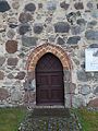 Dorfkirche Bendelin 2017 Portal NE.jpg 3,648 × 4,864; 7.65 MB
-
 Dorfkirche Bendelin 2017 Portal W.jpg 3,648 × 4,864; 8.53 MB
-
 Dorfkirche Bendelin 2017 SE.jpg 3,648 × 4,864; 5.91 MB


