Category:Dorfkapelle (Hatterath)
Jump to navigation
Jump to search
| Object location | | View all coordinates using: OpenStreetMap |
|---|
 | |||||
| Upload media | |||||
| Instance of | |||||
|---|---|---|---|---|---|
| Made from material | |||||
| Location |
| ||||
| Architectural style | |||||
 | |||||
English: Church buildings in Geilenkirchen, Germany
Media in category "Dorfkapelle (Hatterath)"
The following 4 files are in this category, out of 4 total.
-
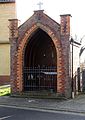 Hatterath Dorfkapelle Hattostraße.jpg 1,700 × 2,400; 438 KB
-
 Hatterath Dorfkapelle Innenansicht.jpg 1,600 × 2,400; 445 KB
-
 Hatterath Dorfkapelle Jahreszahl.jpg 2,400 × 1,600; 416 KB
-
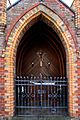 Hatterath Dorfkapelle Schutzgitter.jpg 1,600 × 2,400; 534 KB


