Category:Door County, Wisconsin
Jump to navigation
Jump to search
Counties of Wisconsin: Adams · Ashland · Barron · Bayfield · Brown · Buffalo · Burnett · Calumet · Chippewa · Clark · Columbia · Crawford · Dane · Dodge · Door · Douglas · Dunn · Eau Claire · Florence · Fond du Lac · Forest · Grant · Green · Green Lake · Iowa · Iron · Jackson · Jefferson · Juneau · Kenosha · Kewaunee · La Crosse · Lafayette · Langlade · Lincoln · Manitowoc · Marathon · Marinette · Marquette · Menominee · Milwaukee · Monroe · Oconto · Oneida · Outagamie · Ozaukee · Pepin · Pierce · Polk · Portage · Price · Racine · Richland · Rock · Rusk · Sauk · Sawyer · Shawano · Sheboygan · St. Croix · Taylor · Trempealeau · Vernon · Vilas · Walworth · Washburn · Washington · Waukesha · Waupaca · Waushara · Winnebago · Wood
easternmost county in Wisconsin, United States; a peninsula and nearby islands in Lake Michigan and Green Bay   | |||||
| Upload media | |||||
| Instance of | |||||
|---|---|---|---|---|---|
| Named after | |||||
| Location |
| ||||
| Capital | |||||
| Inception |
| ||||
| Population |
| ||||
| Area |
| ||||
| official website | |||||
 | |||||
English: Media related to Door County, Wisconsin, a county in Wisconsin, United States.
Subcategories
This category has the following 8 subcategories, out of 8 total.
B
G
N
P
T
Media in category "Door County, Wisconsin"
The following 26 files are in this category, out of 26 total.
-
 10 mile radius panel Door County Advocate.jpg 1,214 × 1,518; 490 KB
-
 1998 Door County Tornado Damage.jpg 500 × 375; 36 KB
-
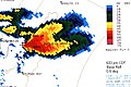 1998 Door County Tornado Radar.jpg 500 × 334; 44 KB
-
 Acres made scarce advertisement Door County Advocate 1970.tif 1,480 × 773; 818 KB
-
Aerial view of Sturgeon Bay Northport Plum Island Detroit Island Washington Island and Rock Island in Door County Wisconsin.webm 5 min 29 s, 1,280 × 720; 27.34 MB
-
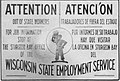 Attention la oficina en Sturgeon Bay Wisconsin.jpg 1,357 × 921; 232 KB
-
 CherryTreeBalatonDoorCountyWisconsin.jpg 1,936 × 1,288; 2.3 MB
-
 Door County Age Distribution, 1930-1960.jpg 1,456 × 2,146; 274 KB
-
 DoorCounty1970Population.svg 751 × 286; 29 KB
-
 DoorCounty2010Population.svg 800 × 600; 26 KB
-
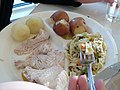 DoorCountyWI FishBoilPlatter.jpg 1,200 × 900; 390 KB
-
 Eagle Harbor, Door County, Wisconsin.png 9,145 × 12,680; 220.26 MB
-
 Gfp-Door-county-chowder.jpg 3,456 × 2,304; 1.1 MB
-
 Kingdom So Delicious advertisement Door County Advocate 1970.tif 1,421 × 718; 719 KB
-
 Listen ad WDOR 1958.png 532 × 552; 206 KB
-
 Little Harbor Welcome Sign.jpg 4,031 × 2,228; 875 KB
-
 Northport beach, Door Peninsula.jpg 3,827 × 2,870; 2.33 MB
-
 PCB panel Door County Advocate.jpg 1,334 × 1,696; 320 KB
-
 Puro Water advertisement Door County Democrat 1914.png 811 × 465; 362 KB
-
 Shivering Sands Natural Area and Cave Point Clay Banks Natual Area.jpg 3,072 × 4,080; 3.82 MB
-
 Sign (25075012216).jpg 3,747 × 2,508; 8.16 MB
-
 Sign on road into Sturgeon Bay, Door County, Wisconsin.tif 4,394 × 3,112; 26.11 MB
-
 SNA Sign (8756105622).jpg 3,872 × 2,592; 1.54 MB
-
 Spray Pumps Door County Advocate 1904.png 776 × 667; 452 KB
-
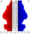 USA Door County, Wisconsin age pyramid.svg 520 × 600; 7 KB
-
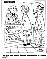
 Wear White After Dark.jpg 411 × 498; 51 KB


.jpg)
.jpg)


