Category:Doopsgezinde kerk, Rottevalle
Jump to navigation
Jump to search
| Object location | | View all coordinates using: OpenStreetMap |
|---|
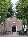
church building in Smallingerland, Netherlands  | |||||
| Upload media | |||||
| Instance of | |||||
|---|---|---|---|---|---|
| Location | Rottevalle, Smallingerland, Friesland, Netherlands | ||||
| Street address |
| ||||
| Located on street |
| ||||
| Heritage designation |
| ||||
| Inception |
| ||||
| Religion or worldview | |||||
| official website | |||||
 | |||||
|
This is a category about rijksmonument number 33994
|
| Address |
|
Media in category "Doopsgezinde kerk, Rottevalle"
The following 8 files are in this category, out of 8 total.
-
 20210917 doopsgezinde kerk Rottevalle.jpg 3,456 × 5,184; 3.85 MB
-
 20210917 steen doopsgezinde kerk Rottevalle.jpg 3,456 × 5,184; 2.97 MB
-
 Doopsgezind efgoed Witveen.jpg 4,608 × 3,072; 2.69 MB
-
 Doopsgezinde kerk Rottevalle.jpg 2,309 × 1,732; 2.87 MB
-
 Doopsgezinde Kerk.JPG 3,456 × 4,608; 3.2 MB
-
 Exterieur, Haven 16 - Rottevalle - 20192687 - RCE.jpg 806 × 1,200; 209 KB
-
 Haven 16 Doopsgezinde kerk Rottevalle (steen).jpg 1,824 × 1,368; 591 KB
-
 Haven 16 Doopsgezinde kerk Rottevalle.jpg 1,368 × 1,824; 851 KB


.jpg)