Category:Doopsgezinde kerk, Makkum
Jump to navigation
Jump to search
| Object location | | View all coordinates using: OpenStreetMap |
|---|
church building in Súdwest-Fryslân, Netherlands  | |||||
| Upload media | |||||
| Instance of | |||||
|---|---|---|---|---|---|
| Part of | |||||
| Location | Makkum, Friesland, Netherlands | ||||
| Street address |
| ||||
| Located on street | |||||
| Architect | |||||
| Heritage designation |
| ||||
| Inception |
| ||||
| Religion or worldview | |||||
| official website | |||||
 | |||||
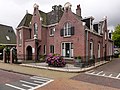
Nederlands: Doopsgezinde Kerk Makkum - anno 1911
|
This is a category about rijksmonument number 516524
|
| Address |
|
Media in category "Doopsgezinde kerk, Makkum"
The following 3 files are in this category, out of 3 total.
-
 2023 Makkumer fermanje.jpg 1,599 × 1,600; 954 KB
-
 Bleekstraat11 Makkum.jpg 3,648 × 2,736; 1.17 MB
-
 Interieur, aanzicht orgel, orgelnummer 935 - Makkum - 20417462 - RCE.jpg 707 × 1,200; 157 KB

