Category:Doopsgezinde Kerk, Middelburg
Jump to navigation
Jump to search
| Object location | | View all coordinates using: OpenStreetMap |
|---|
church building in Middelburg, Netherlands  | |||||
| Upload media | |||||
| Instance of | |||||
|---|---|---|---|---|---|
| Location | Middelburg, Q2863883, Bouches-de-l'Escaut | ||||
| Street address |
| ||||
| Located on street |
| ||||
| Architect | |||||
| Heritage designation |
| ||||
| Inception |
| ||||
| Significant event |
| ||||
| Religion or worldview | |||||
| official website | |||||
 | |||||
|
This is a category about rijksmonument number 508332
|
| Address |
|
Media in category "Doopsgezinde Kerk, Middelburg"
The following 7 files are in this category, out of 7 total.
-
 En Roomse Kerk met Pastorie, prent - Middelburg - 20154667 - RCE.jpg 809 × 1,200; 338 KB
-
 Interieur, aanzicht orgel, orgelnummer 969 - Middelburg - 20417466 - RCE.jpg 2,993 × 3,717; 3.9 MB
-
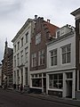 Middelburg Lange Noordstraat58.jpg 2,736 × 3,648; 4.51 MB
-
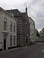 Middelburg Lange Noordstraat62.jpg 2,736 × 3,648; 5.11 MB
-
 Overzicht - Middelburg - 20156932 - RCE.jpg 804 × 1,200; 182 KB
-
 Overzicht - Middelburg - 20156933 - RCE.jpg 804 × 1,200; 168 KB
-
 Overzicht noordwestgevel - Middelburg - 20352500 - RCE.jpg 955 × 1,200; 274 KB


