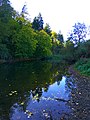
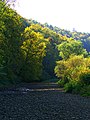
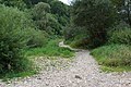
Category:Donauversickerung
Jump to navigation
Jump to search
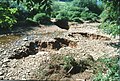
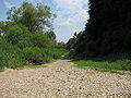
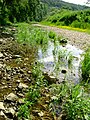
sinkholes seeping water from the Danube for about half the year, and transferring a part of them to the Aachtopf  | |||||
| Upload media | |||||
| Instance of | |||||
|---|---|---|---|---|---|
| Subclass of | |||||
| Location | Baden-Württemberg, Germany | ||||
 | |||||
Media in category "Donauversickerung"
The following 53 files are in this category, out of 53 total.
-
 A Willow - panoramio (1).jpg 4,000 × 3,000; 6.54 MB
-

-
-
-
-

-

-
-
-
 D-BW-Immendingen - Donauversickerung 002.jpg 2,112 × 2,816; 3.52 MB
-
 D-BW-Immendingen - Donauversickerung 003.jpg 2,112 × 2,816; 2.6 MB
-
 D-Immendingen - Donauversickerung 001.JPG 2,816 × 2,112; 3.56 MB
-
 Deutsches Reichsgesetzblatt 37T2 004 0027.jpg 2,335 × 3,390; 581 KB
-
 Donau Immendingen OberhalbVersickerung.JPG 6,016 × 4,000; 6.37 MB
-
 Donau-04-Versickerung-2003-gje.jpg 3,117 × 2,131; 4.08 MB
-
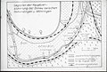
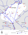
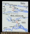
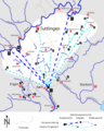 Donau-Aach-System Markierungsversuche.png 3,526 × 4,400; 979 KB
-
 Donauversickerung 1.jpg 1,536 × 2,048; 800 KB
-
 Donauversickerung 2.jpg 1,536 × 2,048; 703 KB
-
 Donauversickerung bei Immendingen - panoramio (1).jpg 3,264 × 2,448; 1.76 MB
-
 Donauversickerung bei Immendingen - panoramio (2).jpg 3,264 × 2,448; 1.73 MB
-
 Donauversickerung bei Immendingen - panoramio (3).jpg 3,264 × 2,448; 1.78 MB
-
 Donauversickerung bei Immendingen - panoramio (4).jpg 3,264 × 2,448; 1.78 MB
-
 Donauversickerung bei Immendingen - panoramio (5).jpg 3,264 × 2,448; 3.25 MB
-
 Donauversickerung bei Immendingen - panoramio.jpg 3,264 × 2,448; 1.83 MB
-
 Donauversickerung bei Immendingen 2080-HDR-Pano.jpg 10,209 × 8,153; 65.41 MB
-
 Donauversickerung01.JPG 2,272 × 1,712; 1.63 MB
-
 Donauversickerung01.jpg 1,001 × 667; 127 KB
-
 Donauversickerung02.JPG 2,272 × 1,712; 1.37 MB
-
 Donauversinkung bei Immendingen 2089.jpg 8,256 × 5,504; 34.5 MB
-
 Donauversinkung bei Immendingen 2092-Pano.jpg 9,971 × 8,204; 53.5 MB
-
 Donauversinkung bei Immendingen 2107-Pano.jpg 14,193 × 7,430; 67.07 MB
-
 Donauversinkung Diagramm Vollversickerungstage 1883-2019.svg 763 × 495; 44 KB
-
 Donauversinkung Markierungsversuche.png 3,526 × 4,400; 941 KB
-
 Donauversinkung Schild.jpg 1,452 × 1,064; 152 KB
-
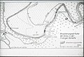
 Donauversinkung-Schema.png 574 × 548; 222 KB
-
 Donauversinkung.jpg 2,560 × 1,920; 4.49 MB
-
 Dried Up River Bed - panoramio.jpg 3,000 × 4,000; 4.95 MB
-
 Einoedtalviadugt.jpg 4,000 × 2,250; 3.65 MB
-
 ETH-BIB-Donau-Verstrickung-Dia 247-Z-00333.tif 2,945 × 3,409; 28.83 MB
-
 Fridingen an der Donau - Versickerungsstellen.JPG 3,584 × 2,016; 2.3 MB
-
 Grafik Donauversickerung.png 1,169 × 854; 116 KB
-
Hattinger Vobindungskurve.webm 34 min 23 s, 1,920 × 1,080; 1.38 GB
-
 Here The Danube Disappears - panoramio.jpg 3,000 × 4,000; 3.86 MB
-
 Immendingen Donauversickerung 20080714 1.jpg 1,280 × 960; 795 KB
-
 Information - panoramio (3).jpg 3,000 × 4,000; 3.94 MB
-
 Schluckloch-immendingen.jpg 1,600 × 1,200; 909 KB
-
 Stones Only - panoramio.jpg 3,000 × 4,000; 5.28 MB
-
 The Danube Without Water - panoramio.jpg 4,000 × 3,000; 5.54 MB
-
 The Same Place Just Without Water - panoramio.jpg 4,000 × 3,000; 6.32 MB
-
 The Water Disapears - panoramio.jpg 4,000 × 3,000; 5.26 MB
-
 Tuttlingen-Möhringen Donauversickerung 01.jpg 6,000 × 4,000; 18.78 MB
-
 Tuttlingen-Möhringen Donauversickerung 02.jpg 6,000 × 4,000; 16.63 MB
-
 Tuttlingen-Möhringen Donauversickerung 03.jpg 4,000 × 6,000; 17.87 MB
.jpg)


.jpg)
.jpg)
.jpg)
.jpg)
.jpg)


.jpg)


Categories:
- Danube in Immendingen
- Oberes Donautal
- Intermittent rivers in Germany
- Stream capture in Germany
- Fluvial geomorphology of Baden-Württemberg
- Partially subterranean rivers in Germany
- FFH-Gebiet Nördliche Baaralb und Donau bei Immendingen
- Geotopes in Baden-Württemberg
- GeoPark Schwäbische Alb
- Intermittent rivers in Baden-Württemberg
- Ponors in Baden-Württemberg
- Losing streams in Germany
- Geotourism in Baden-Württemberg