Category:Donatuskerk (Leermens)
Jump to navigation
Jump to search
| Object location | | View all coordinates using: OpenStreetMap |
|---|
church building in Loppersum, Netherlands  | |||||
| Upload media | |||||
| Instance of | |||||
|---|---|---|---|---|---|
| Dedicated to | |||||
| Location | Leermens, Eemsdelta, Groningen, Netherlands | ||||
| Street address |
| ||||
| Located on street |
| ||||
| Heritage designation |
| ||||
| Inception |
| ||||
| official website | |||||
 | |||||
|
This is a category about rijksmonument number 40301
|
| Address |
|
Subcategories
This category has only the following subcategory.
I
Media in category "Donatuskerk (Leermens)"
The following 40 files are in this category, out of 40 total.
-
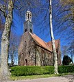 Donatustsjerke fan Leermens.jpg 2,245 × 2,492; 3.19 MB
-
 Donatustsjerke, Leermens.jpg 2,239 × 2,452; 2.97 MB
-
 Gevel noord-transept - Leermens - 20130260 - RCE.jpg 901 × 1,200; 329 KB
-
 Gevel van het zuid-transept - Leermens - 20130258 - RCE.jpg 909 × 1,200; 307 KB
-
 INTERIEUR, TEKENING VAN DE PLATTEGROND - Leermens - 20265910 - RCE.jpg 1,200 × 982; 77 KB
-
 INTERIEUR, TEKENING VAN PLATTEGRONDEN - Leermens - 20265911 - RCE.jpg 1,200 × 807; 56 KB
-
 Kerk naar het noord-westen - Leermens - 20130240 - RCE.jpg 1,200 × 878; 245 KB
-
 Kerk naar het zuid-westen - Leermens - 20130241 - RCE.jpg 888 × 1,200; 252 KB
-
 Kerk vanuit het noord-oosten - Leermens - 20130243 - RCE.jpg 1,200 × 884; 262 KB
-
 Kerk vanuit het zuid-oosten - Leermens - 20130232 - RCE.jpg 1,200 × 859; 218 KB
-
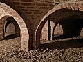
 Leermens - Donatuskerk - catacombes.jpg 4,896 × 3,264; 19.21 MB
-
 Leermens - Donatuskerk - zijaanzicht.jpg 3,323 × 2,493; 3.02 MB
-
 Leermens - kerk - doksaal.jpg 2,736 × 3,648; 1.46 MB
-
 Leermens - kerk - gewelven (2).jpg 3,648 × 2,736; 2.01 MB
-
 Leermens - kerk - gewelven.jpg 3,648 × 2,736; 2.34 MB
-
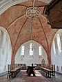 Leermens - kerk - koor.jpg 2,736 × 3,648; 2.36 MB
-
 Leermens - kerk - kroonluchter.jpg 2,736 × 3,648; 2.6 MB
-
 Noord-gevel van het koor - Leermens - 20130236 - RCE.jpg 957 × 1,200; 375 KB
-
 Noord-gevel van het schip - Leermens - 20130234 - RCE.jpg 1,200 × 889; 328 KB
-
 Opgraving fundering aan de west-zijde van de kerk - Leermens - 20130231 - RCE.jpg 1,200 × 1,181; 372 KB
-
 Opgraving fundering aan de west-zijde van de kerk - Leermens - 20378684 - RCE.jpg 1,200 × 1,178; 425 KB
-
 Opgraving ten westen van de kerk - Leermens - 20130242 - RCE.jpg 960 × 1,200; 369 KB
-
 Overzicht van fundering voormalig oksaal - Leermens - 20130252 - RCE.jpg 1,200 × 951; 307 KB
-
 Overzicht zuid-zijde - Leermens - 20130257 - RCE.jpg 1,200 × 964; 325 KB
-
 Peters - Donatuskerk.jpg 812 × 818; 780 KB
-
 Plattegrond - Leermens - 20130268 - RCE.jpg 1,200 × 784; 114 KB
-
 PMa NL 006 Leermens.jpg 600 × 484; 409 KB
-

-

-

-

-

-

-
 Romanogotische kerk van Leermens.jpg 1,944 × 2,592; 738 KB
-
 Schip en transept vanuit het zuid zuid-oosten - Leermens - 20130233 - RCE.jpg 859 × 1,200; 280 KB
-
 West-gevel naar het oosten - Leermens - 20130261 - RCE.jpg 972 × 1,200; 414 KB
-
 Zicht op zuidoostgevel met grafzerk op de voorgrond - Leermens - 20364715 - RCE.jpg 1,181 × 1,200; 471 KB
-
 Zicht vanuit het zuidoosten - Leermens - 20325693 - RCE.jpg 1,200 × 962; 283 KB
-
 Zuid-gevel naar het oosten - Leermens - 20130259 - RCE.jpg 903 × 1,200; 290 KB
-
 Zuid-gevel van het schip - Leermens - 20130235 - RCE.jpg 1,200 × 905; 336 KB


.jpg)


