Category:Dommitzsch, Torgauer Straße 30
Jump to navigation
Jump to search
| Object location | | View all coordinates using: OpenStreetMap |
|---|
| (Wikidata) |
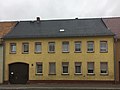
Deutsch: Ackerbürgerhaus in geschlossener Bebauung in Dommitzsch, Torgauer Straße 30; errichtet 1. Hälfte 19. Jh.; Putzbau mit seitlicher Toreinfahrt, baugeschichtlich, ortsgeschichtlich und ortsbildprägend von Bedeutung; 1717 als Gasthaus erwähnt; Kulturdenkmal
English: Residential house of a farming citizen in closed development in Dommitzsch, Torgauer Straße 30; built 1st half of the 19th century; plaster construction with lateral gate entrance, building historical and local historical importance and town scape formative; 1717 mentioned as an inn; cultural heritage monument
house in Dommitzsch, Germany | |||||
| Upload media | |||||
| Instance of | |||||
|---|---|---|---|---|---|
| Location | Dommitzsch, Nordsachsen, Saxony, Germany | ||||
| Street address |
| ||||
| Heritage designation | |||||
| Inception |
| ||||
 | |||||
Media in category "Dommitzsch, Torgauer Straße 30"
The following 3 files are in this category, out of 3 total.
-
 Dommitzsch, Torgauer Straße 30 (1).jpg 3,414 × 2,560; 5.1 MB
-
 Dommitzsch, Torgauer Straße 30 (2).jpg 3,567 × 2,675; 5.65 MB
-
 Dommitzsch, Torgauer Straße 30 (3).jpg 3,660 × 2,745; 6.12 MB
.jpg)
.jpg)
.jpg)