Category:Disused railway lines in Nottinghamshire
Jump to navigation
Jump to search
Subcategories
This category has the following 8 subcategories, out of 8 total.
Media in category "Disused railway lines in Nottinghamshire"
The following 37 files are in this category, out of 37 total.
-
 Abandoned Branch Line - geograph.org.uk - 155939.jpg 640 × 480; 92 KB
-
 Abandoned Railway - geograph.org.uk - 141931.jpg 640 × 480; 74 KB
-
 Abandoned railway - geograph.org.uk - 3903343.jpg 1,024 × 768; 133 KB
-
 Abandoned track - geograph.org.uk - 3068826.jpg 1,024 × 768; 284 KB
-
 Blidworth & Rainworth Station (remains) 1833983 0f90bd9e.jpg 640 × 416; 135 KB
-
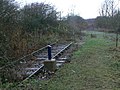
 Bridleway across the branch - geograph.org.uk - 1622462.jpg 479 × 640; 113 KB
-
 Bridleway to Stragglethorpe - geograph.org.uk - 1622463.jpg 640 × 478; 100 KB
-

-
 Clipstone Railway - geograph.org.uk - 754084.jpg 640 × 428; 125 KB
-
 Disused railway - geograph.org.uk - 644560.jpg 640 × 480; 144 KB
-
 Disused railway - geograph.org.uk - 644563.jpg 480 × 640; 164 KB
-
 Disused railway line - geograph.org.uk - 654608.jpg 640 × 356; 73 KB
-
 Footpath to Hucknall - geograph.org.uk - 661618.jpg 480 × 640; 110 KB
-
 Former colliery railway - geograph.org.uk - 1622458.jpg 640 × 479; 120 KB
-
 Former colliery railway - geograph.org.uk - 1622459.jpg 640 × 479; 116 KB
-
 Former colliery railway - geograph.org.uk - 1622460.jpg 479 × 640; 108 KB
-
 Former railway line - geograph.org.uk - 1323359.jpg 640 × 479; 188 KB
-
 Hucknall Road Triangle - geograph.org.uk - 1206786.jpg 640 × 479; 152 KB
-
 Hucknall Road Triangle - geograph.org.uk - 1206791.jpg 640 × 479; 97 KB
-
 Land near King's Clipstone, Notts. - geograph.org.uk - 18299.jpg 480 × 640; 164 KB
-
 Leaves on the Line - geograph.org.uk - 174787.jpg 640 × 480; 184 KB
-
 Of gorse it is - geograph.org.uk - 170517.jpg 640 × 480; 290 KB
-
 Old Embankment - geograph.org.uk - 194746.jpg 640 × 480; 88 KB
-
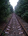
 Old railway line - geograph.org.uk - 1557704.jpg 479 × 640; 149 KB
-
 Old railway, Sherwood Pines Forest Park. - geograph.org.uk - 66435.jpg 503 × 640; 146 KB
-
 Railway Bridge near Stragglethorpe - geograph.org.uk - 161593.jpg 640 × 427; 155 KB
-
 Railway track bed - geograph.org.uk - 1588807.jpg 640 × 424; 98 KB
-
 Railway trail - geograph.org.uk - 1206796.jpg 479 × 640; 118 KB
-
 Rusty Rails - geograph.org.uk - 166177.jpg 640 × 480; 92 KB
-
 Rusty Rails and Gate - geograph.org.uk - 166183.jpg 640 × 480; 106 KB
-
 Site of railway sidings - geograph.org.uk - 1206770.jpg 640 × 479; 90 KB
-
 The Railway Children^ - geograph.org.uk - 1215901.jpg 640 × 480; 212 KB
-
 The railway to Calverton Colliery - geograph.org.uk - 661617.jpg 459 × 640; 146 KB
-
 Track Bed - geograph.org.uk - 183048.jpg 640 × 480; 119 KB
-
 Trackside gorse - geograph.org.uk - 711245.jpg 640 × 427; 98 KB
-
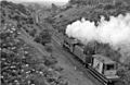
 Twas not always so peaceful (1) - geograph.org.uk - 737751.jpg 640 × 480; 169 KB
-
 Twas not always so peaceful (2) - geograph.org.uk - 737749.jpg 640 × 480; 259 KB


_1833983_0f90bd9e.jpg)


_-_geograph.org.uk_-_737751.jpg)
_-_geograph.org.uk_-_737749.jpg)