Category:Distant views of Milldown, Dumfries and Galloway
Jump to navigation
Jump to search
Media in category "Distant views of Milldown, Dumfries and Galloway"
The following 15 files are in this category, out of 15 total.
-
 At the summit of Meikle Millyea - geograph.org.uk - 1145666.jpg 640 × 480; 67 KB
-
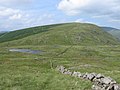 Below Meikle Millyea to Milldown - geograph.org.uk - 207761.jpg 640 × 480; 78 KB
-

-
 Black Spots and Milldown Hills - geograph.org.uk - 758156.jpg 640 × 480; 93 KB
-
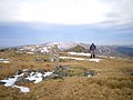
 Cairn on Meikle Millyea - geograph.org.uk - 1115636.jpg 640 × 480; 97 KB
-

-
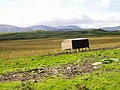 Feeding station on Hannayston Hill - geograph.org.uk - 549760.jpg 640 × 480; 108 KB
-
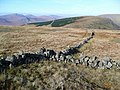 Junction of walls on Meikle Millyea - geograph.org.uk - 1541033.jpg 640 × 480; 104 KB
-
 Loch Dungeon. - geograph.org.uk - 515921.jpg 640 × 480; 96 KB
-
 McAdam's Glen, Forrest Estate - geograph.org.uk - 515894.jpg 640 × 480; 120 KB
-

-

-

-
 Summit cairn on Millfire - geograph.org.uk - 1540201.jpg 640 × 480; 77 KB
-
 The craggy face of Milldown - geograph.org.uk - 1115697.jpg 640 × 480; 90 KB


_from_the_Southern_slopes_of_Cairnsmore_of_Carsphairn_-_geograph.org.uk_-_435289.jpg)


