Category:Dirleton Kirk
Jump to navigation
Jump to search
| Object location | | View all coordinates using: OpenStreetMap |
|---|
church in East Lothian, Scotland, UK  | |||||
| Upload media | |||||
| Instance of | |||||
|---|---|---|---|---|---|
| Location |
| ||||
| Heritage designation |
| ||||
 | |||||
Media in category "Dirleton Kirk"
The following 4 files are in this category, out of 4 total.
-
 Church in Dirleton - geograph.org.uk - 618200.jpg 640 × 480; 44 KB
-
 Dirleton Church of Scotland - geograph.org.uk - 637724.jpg 640 × 480; 88 KB
-
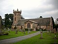 Dirleton Kirk.jpg 640 × 480; 66 KB
-
 Dirleton Parish Church - geograph.org.uk - 29537.jpg 640 × 480; 126 KB


