Category:Dimmuborgir
Jump to navigation
Jump to search
Deutsch: Der erodierte Lavasee Dimmuborgier gehört zum Heiðarsporðar-Vulkansystem im Norden s beim See Mývatn. Er liegt östlich des Sees zwischen diesem und dem Tuffring Hverfjall und steht unter Naturschutz.
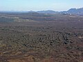
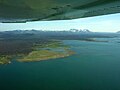
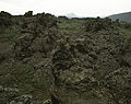
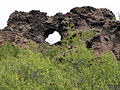
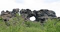
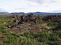
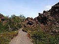
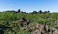
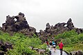
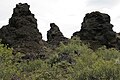
English: Dimmuborgir is a large area of unusually shaped lava fields east of Mývatn in Iceland. The Dimmuborgir area is composed of various volcanic caves and rock formations, reminiscent of an ancient collapsed citadel (hence the name). The dramatic structures are one of Iceland's most popular natural tourist attractions. The Dimmuborgir area consists of a massive, collapsed lava tube formed by a lava lake. These lavas had their origin in a large eruption in the Þrengslaborgir and Lúdentsborgir crater rows to the east, about 2300 years ago.
Français : Le Dimmuborgir est une formation volcanique située dans la région du lac Mývatn, en Islande. Son nom, signifiant « châteaux sombres », est dû aux formations de lave en forme de colonnes. Ces formations sont dues à l'érosion d'un lac de lave situé à l'origine sur des terrains humides.
Íslenska: Dimmuborgir eru einstæðar hraunmyndanir við austanvert Mývatn. Myndun Dimmuborga: Hraunið sem rann þegar Dimmuborgir mynduðust kom frá eldgosi í Lúdentsborgum og Þrengslaborgum fyrir um 2000 árum og er það mesta hraungos sem orðið hefur á Mývatnssvæðinu eftir ísöld. Dimmuborgir eru staðsettar í lægð og er talið að þegar þær mynduðust hafi hraun frá fyrrnefndu gosi streymt í þessa lægð og smám saman fyllt hana af bráðnu hrauni. Á meðan á þessu stóð tók yfirborð hraunsins að storkna og sumstaðar storknaði það til botns og myndaði þá hraunstólpa sem fólk sér þegar það gengur um svæðið í dag. Storkið hraunið myndaði nokkurskonar þak ofan á bráðinni kvikunni en á endanum braust hraunið fram og tæmdist undan þakinu. Við þetta veiktist þakið svo að það hrundi niður og eftir varð það einstæða landslag sem flestir þekkja í dag sem Dimmuborgir.
Nederlands: Dimmuborgir (duistere burchten) is een natuurreservaat op noord IJsland bij het Mývatn dat zich kenmerkt door zeer grillige en grote rotsformaties die bestaan uit vulkanisch gesteente dat ontstond bij vulkanische uitbarstingen van ongeveer 3000 jaar geleden. Het afgekoelde lava lag waarschijnlijk op een zachte onderlaag, en toen die eenmaal was weggespoeld stortte het lavadak in.
Norsk nynorsk: Dimmuborgir er eit stort område med uvanlege lavaformasjonar på ei lavaslette aust for Mývatn på Island. Dimmuborgir-området består av forskjellige grotter og steinformasjonar som er restar etter vulkansk aktivitet. Området kan sjå ut som restane etter ein oldgamal kollapsa festning med søyler som spyr ut røykfaner med svovelhaldig røyk. I islandske myter var Dimmuborgir ein stad mellom jorda og underverda, og skal ha vore bustad for alvar, troll og julenissen.
large area of unusually shaped lava fields east of Mývatn in Iceland  | |||||
| Upload media | |||||
| Instance of |
| ||||
|---|---|---|---|---|---|
| Location | Þingeyjarsveit, Northeastern Region, Iceland | ||||
 | |||||
Subcategories
This category has the following 9 subcategories, out of 9 total.
+
- Panoramics of Dimmuborgir (7 F)
D
- Dimmuborgir viewpoint (2 F)
F
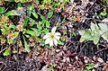
- Flora of Dimmuborgir (4 F)
H
- Hverfjall from Dimmuborgir (2 F)
K
- Kirkjan (Dimmuborgir) (13 F)
M
- Mývatn from Dimmuborgir (1 F)
R
W
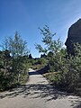
- Walking paths in Dimmuborgir (13 F)
Media in category "Dimmuborgir"
The following 66 files are in this category, out of 66 total.
-
 20040626.Lava fields in Iceland.-019.jpg 5,280 × 3,960; 2.99 MB
-
 2005-05-28 Dimmuborgir 360.jpg 13,484 × 1,421; 8.97 MB
-
 2008-05-19 22 Near Dimmuborgir.jpg 5,894 × 1,388; 3.38 MB
-
 2014-05-03 13-37-17 Iceland - Mývatni Reykjahlíð 5h 224°.JPG 13,114 × 2,397; 17.98 MB
-
 65 Dimmuborgir (9).JPG 4,000 × 3,000; 2.55 MB
-
 Aerial View of Dimmuborgir 21.05.2008 15-25-17.JPG 2,048 × 1,536; 1.04 MB
-
 Aerial View of Mývatn 21.05.2008 16-05-12.JPG 2,048 × 1,536; 920 KB
-
 Aschekrater Hverfjall 6070.JPG 3,888 × 2,592; 4.2 MB
-
 Auf dem Lavafeld Dimmuborgir 6059.JPG 1,248 × 1,649; 1.47 MB
-
 Dimmuborgir (1.jpg 3,872 × 2,592; 2.29 MB
-
 Dimmuborgir (2).jpg 3,872 × 2,592; 2.35 MB
-
 Dimmuborgir (3).jpg 3,872 × 2,592; 2.33 MB
-
 Dimmuborgir (3795434369).jpg 4,272 × 2,840; 4.67 MB
-
 Dimmuborgir (3796251436).jpg 4,272 × 2,840; 4.15 MB
-
 Dimmuborgir (4674553921).jpg 1,420 × 2,136; 877 KB
-
 Dimmuborgir (6).jpg 3,872 × 2,592; 2.27 MB
-
 Dimmuborgir (9).jpg 3,872 × 2,592; 2.25 MB
-
 Dimmuborgir - panoramio (1).jpg 3,648 × 2,432; 4.95 MB
-
 Dimmuborgir - panoramio (3).jpg 3,648 × 2,432; 11.66 MB
-
 Dimmuborgir - panoramio (4).jpg 3,648 × 2,736; 12.06 MB
-
 Dimmuborgir - panoramio (5).jpg 3,648 × 2,432; 4.8 MB
-
 Dimmuborgir 01.jpg 5,408 × 4,237; 21.01 MB
-
 Dimmuborgir 02.jpg 5,373 × 4,290; 22.47 MB
-
 Dimmuborgir 03.jpg 5,434 × 4,290; 27.09 MB
-
 Dimmuborgir 1 - panoramio.jpg 4,928 × 3,264; 11.17 MB
-
 Dimmuborgir 2 - panoramio.jpg 4,928 × 3,264; 10.56 MB
-
 Dimmuborgir 3 - panoramio.jpg 3,264 × 4,928; 11.8 MB
-
 Dimmuborgir 4 - panoramio.jpg 4,928 × 3,264; 10.27 MB
-
 Dimmuborgir entrance.jpg 3,872 × 2,592; 2.26 MB
-
 Dimmuborgir Iceland 01.jpg 2,272 × 1,704; 1.37 MB
-
 Dimmuborgir lava (1417076225).jpg 2,048 × 1,109; 555 KB
-
 Dimmuborgir Lava Field - 2013.08 - panoramio (1).jpg 4,608 × 2,592; 3.03 MB
-
 Dimmuborgir Lava Field - 2013.08 - panoramio (2).jpg 4,555 × 3,416; 3.82 MB
-
 Dimmuborgir Lava Field - 2013.08 - panoramio.jpg 4,608 × 3,456; 4.01 MB
-
 Dimmuborgir lava field - panoramio.jpg 1,306 × 828; 416 KB
-
 Dimmuborgir lava structure.jpg 4,048 × 3,036; 4.37 MB
-
 Dimmuborgir Silhouette (14602739440).jpg 2,560 × 1,441; 355 KB
-
 Dimmuborgir, Iceland - Eric Marchese.jpg 3,264 × 2,448; 3.52 MB
-
 Dimmuborgir, Iceland 04.jpg 5,580 × 3,720; 15.08 MB
-
 Dimmuborgir, Iceland 05.jpg 5,362 × 3,142; 12.6 MB
-
 Dimmuborgir, Iceland 2 - Eric Marchese.jpg 3,264 × 2,448; 3.43 MB
-
 Dimmuborgir-stígur.jpg 1,500 × 1,125; 1.58 MB
-
 Fálki (Falco rusticolus) - Gyr Falcon (cropped).jpg 1,190 × 1,862; 663 KB
-
 Fálki (Falco rusticolus) - Gyr Falcon.jpg 4,000 × 3,470; 2.2 MB
-
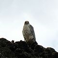 Gyrfalcon at Lake Myvatn by Bruce McAdam.jpg 600 × 600; 186 KB
-
 Hallarflöt at Dimmuborgir.jpg 3,568 × 2,368; 2.42 MB
-
 Iceland (20022679622).jpg 3,264 × 2,448; 2.7 MB
-
 Iceland 2023 H07.jpg 3,060 × 4,080; 4.11 MB
-
 Iceland, Dimmuborgir, Volcanic Rock Formations - panoramio.jpg 1,920 × 1,080; 731 KB
-
 IcelandDimmuborgir2005.jpg 1,827 × 1,020; 756 KB
-
 IS-myvatn-dimmuborgir-lava-pflanzen-1.jpg 4,928 × 3,264; 5.87 MB
-
 IS-myvatn-dimuborgir-irrgarten-01.jpg 4,928 × 3,264; 4.73 MB
-
 IS-myvatn-dimuborgir-irrgarten-02.jpg 4,928 × 3,264; 5.19 MB
-
 IS-myvatn-dimuborgir-myvatn-01.jpg 4,928 × 3,264; 3.8 MB
-
 Lava formations at Hallarflöt at Dimmuborgir.jpg 3,568 × 2,368; 2.36 MB
-
 Lava pillar at Dimmuborgir.jpg 2,368 × 3,568; 2.07 MB
-
 Lavafeld Dimmuborgir 6060.JPG 3,888 × 836; 2.22 MB
-
 Lavafeld Dimmuborgir 6063.JPG 2,463 × 2,463; 4.83 MB
-
 Lavafeld Dimmuborgir 6066.JPG 3,567 × 2,378; 7.62 MB
-
 Lavafeld Dimmuborgir 6074.JPG 3,802 × 2,434; 4.64 MB
-
 Les châteaux sombres (5019142220).jpg 5,184 × 3,456; 8.52 MB
-
 Mountains view from Dimmuborgir.jpg 3,568 × 2,368; 2.07 MB
-
 Mývatn Dimmuborgir Panorama 01.jpg 22,559 × 2,456; 15.7 MB
-
 Mývatn, Dimmuborgir (6803376833).jpg 4,272 × 2,848; 5.54 MB
-
 Roadsign-to-Dimmuborgir.jpg 3,456 × 2,304; 3.91 MB
-
 View of Dimmuborgir from parking.jpg 3,568 × 2,368; 3.26 MB

.JPG)


.jpg)
.jpg)
.jpg)
.jpg)
.jpg)
.jpg)
.jpg)
.jpg)
.jpg)
.jpg)
.jpg)


.jpg)
.jpg)
.jpg)


.jpg)


_-_Gyr_Falcon_(cropped).jpg)
_-_Gyr_Falcon.jpg)

.jpg)


.jpg)

.jpg)


Categories:
- Lava fields in Iceland
- Mývatn
- Rock formations in Iceland
- Hills of Iceland
- Huldufólk
- Lava pools (eroded)
- Rock formations in Norðurland eystra
- Laxárhraun yngra (Younger Laxá Lava)
- Remnants of lava ponds
- Volcanic landforms of the Mývatn region
- Volcanic landforms of the Heiðarsporðar volcanic system
- Rocks and minerals of the Heiðarsporðar volcanic system
- Heiðarsporðar volcanic system
- Basalts of the Heiðarsporðar volcanic system
- Lava pools in Iceland
- Lava tubes (eroded)
- Game of Thrones filming locations and production sets
- Lava tubes of the Heiðarsporðar volcanic system
- Grýla (mythological person in Iceland)
- Christmas lads
- Folk tale locations in Iceland
- Basalt formations in Iceland
- Protected areas of Iceland