Category:Diehsa, Wegestein Zum Lurchenberg
Jump to navigation
Jump to search
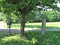
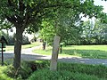
Deutsch: Wegestein von verkehrsgeschichtlicher Bedeutung in Diehsa
English: Historic way stone in Diehsa
| Object location | | View all coordinates using: OpenStreetMap |
|---|
| (Wikidata) |
.jpg) | |||||
| Upload media | |||||
| Instance of | |||||
|---|---|---|---|---|---|
| Location | Waldhufen, Q878995, Görlitz, Saxony, Germany | ||||
| Street address |
| ||||
| Heritage designation | |||||
 | |||||
Media in category "Diehsa, Wegestein Zum Lurchenberg"
The following 6 files are in this category, out of 6 total.
-
 Diehsa Wegestein Zum Lurchenberg (1).jpg 4,416 × 3,312; 4.96 MB
-
 Diehsa Wegestein Zum Lurchenberg (2).jpg 4,416 × 3,312; 4.63 MB
-
 Diehsa Wegestein Zum Lurchenberg (3).jpg 4,416 × 3,312; 4.39 MB
-
 Diehsa Wegestein Zum Lurchenberg (4).jpg 4,416 × 3,312; 6.52 MB
-
 Diehsa Wegestein Zum Lurchenberg (5).jpg 4,416 × 3,312; 6.36 MB
-
 Diehsa Wegestein Zum Lurchenberg (6).jpg 4,416 × 3,312; 5.37 MB
.jpg)
.jpg)
.jpg)
.jpg)
.jpg)