Category:Die Vergulde Craen
Jump to navigation
Jump to search
| Object location | | View all coordinates using: OpenStreetMap |
|---|
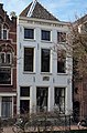
house in Utrecht, Netherlands  | |||||
| Upload media | |||||
| Instance of | |||||
|---|---|---|---|---|---|
| Location | Utrecht, Netherlands | ||||
| Street address |
| ||||
| Located on street |
| ||||
| Heritage designation |
| ||||
 | |||||
|
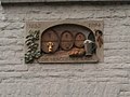
This is a category about rijksmonument number 36485
|
| Address |
|
Media in category "Die Vergulde Craen"
The following 3 files are in this category, out of 3 total.
-
 Oudegracht 17 Utrecht.jpg 2,101 × 3,194; 2.1 MB
-
 Rijksmonument-36485-20110913123205.jpg 2,048 × 1,536; 442 KB
-
 Voorgevel - Utrecht - 20236437 - RCE.jpg 808 × 1,200; 223 KB

