Category:Dicker Heinrich (Burg Querfurt)
Jump to navigation
Jump to search
| Object location | | View all coordinates using: OpenStreetMap |
|---|
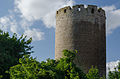
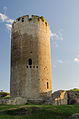
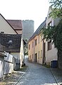
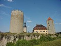
English: 12. century, 27.5 m tall, 14 m wide round tower.
Media in category "Dicker Heinrich (Burg Querfurt)"
The following 19 files are in this category, out of 19 total.
-
 19881003211NR Querfurt Burg Querfurt Dicker Heinrich.jpg 3,000 × 2,280; 4.12 MB
-
 Burg Querfurt-035.jpg 2,448 × 3,264; 4.28 MB
-
 Querfurt, Burg, Dicker Heinrich und Pariser Turm-001.jpg 4,173 × 2,764; 6.82 MB
-
 Querfurt, Burg, Dicker Heinrich, Pariser Turm-001.jpg 4,144 × 2,745; 6.66 MB
-
 Querfurt, Burg, Dicker Heinrich-001.jpg 4,419 × 2,927; 7.56 MB
-
 Querfurt, Burg, Dicker Heinrich-002.jpg 4,772 × 3,161; 9.82 MB
-
 Querfurt, Burg, Dicker Heinrich-004.jpg 4,238 × 2,807; 6.13 MB
-
 Querfurt, Burg, Dicker Heinrich-008.jpg 4,547 × 3,012; 8.44 MB
-
 Querfurt, Burg, Dicker Heinrich-009.jpg 3,930 × 2,603; 7 MB
-
 Querfurt, Burg, Dicker Heinrich-010.jpg 3,096 × 4,674; 8.02 MB
-
 Querfurt, Burg, Dicker Heinrich-011.jpg 4,928 × 3,264; 8.44 MB
-
 Querfurt, Burg, Dicker Heinrich-012.jpg 4,928 × 3,264; 9.15 MB
-
 Querfurt, Burg, Dicker Heinrich-013.jpg 3,581 × 2,372; 4.77 MB
-
 Querfurt, Burg, Dicker Heinrich-014.jpg 4,575 × 3,030; 8.15 MB
-
 Querfurt, Burg, Dicker Heinrich-015.jpg 4,791 × 3,173; 8.93 MB
-
 Querfurt, Burg, Dicker Heinrich-022.jpg 4,467 × 2,959; 6.41 MB
-
 Querfurt, Burg, Dicker Heinrich-032.jpg 4,022 × 2,664; 7.58 MB
-
 Querfurt, die Brunnenstraße, Blick zum Bergfried "Dicker Heinrich".jpg 3,273 × 4,463; 2.96 MB
-
 Querfurt3.jpg 800 × 600; 69 KB


