Category:Diagrams of volcanic landforms
Jump to navigation
Jump to search
Subcategories
This category has the following 7 subcategories, out of 7 total.
Media in category "Diagrams of volcanic landforms"
The following 9 files are in this category, out of 9 total.
-
 Boschungswinkelrp.jpg 405 × 232; 19 KB
-
 Pseudocrater Skútusstaðir map.svg 606 × 458; 143 KB
-
 PSM V40 D233 Lava block under water in soft sandy mud.jpg 1,410 × 907; 418 KB
-
 PSM V40 D235 Lava ridges smoothed by ice sheet.jpg 1,119 × 1,518; 302 KB
-
 PSM V40 D235 Volcanic ridge in greenland.jpg 1,079 × 240; 58 KB
-
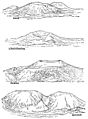
 PSM V40 D238 Progressive erosion of a volcanic cone.jpg 855 × 1,107; 83 KB
-
 PSM V40 D242 Diagonally exposed model of the rock layer formation.jpg 1,100 × 799; 174 KB
-

-
 Volcanic mountain.png 1,487 × 752; 197 KB


