Category:Diagrams of fluvial terraces
Jump to navigation
Jump to search
Media in category "Diagrams of fluvial terraces"
The following 25 files are in this category, out of 25 total.
-
 403 of 'Text-Book of Geology' (11085152314).jpg 1,100 × 212; 53 KB
-
 A series of paired river terraces plainsvg.svg 1,904 × 2,165; 75 KB
-
 A series of paired river terraces.jpg 2,456 × 2,344; 639 KB
-
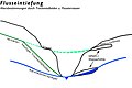 Altersbestimmung-Gefälleknick Laucherteintiefung Schwäbische Alb.jpg 1,800 × 1,200; 395 KB
-
 BenchCrossSection.tif 2,796 × 1,363; 10.94 MB
-
 Corte geomorfológico del Trabancos.gif 1,024 × 275; 86 KB
-
 Cross-section of typikal terrase.png 1,464 × 1,147; 212 KB
-

-
 Dolina Wisły w Warszawie - taras zalewowy i in.gif 800 × 477; 42 KB
-
 Flussterasser.png 802 × 251; 126 KB
-
 FluvialTerraces.jpg 1,104 × 327; 227 KB
-
 FluvialTerraces2.jpg 4,611 × 1,360; 3.05 MB
-
 Lits d'un fleuve.png 825 × 388; 6 KB
-
 NestedFluvialTerracesDetailed.jpg 2,708 × 1,015; 690 KB
-
 NestedFluvialTerracesGeneral.jpg 2,708 × 1,015; 614 KB
-
 Plate 15 Map of the Shore Embankments.jpg 1,392 × 1,943; 177 KB
-
 Plate 16 Map of the North Group.jpg 1,378 × 1,865; 209 KB
-
 Plate 17 Map of the Middle Group.jpg 1,357 × 1,945; 130 KB
-
 Plate 18 Map of the South Group.jpg 1,404 × 1,974; 126 KB
-
 Plate 19 Map of the Snowplow.jpg 1,397 × 1,936; 208 KB
-
 Plate 20 Map of the Pass Between Rush and Toole Valleys -Wave Built Barrier.jpg 1,391 × 1,917; 203 KB
-
 Plate 21 Map of Shore Bars and Terraces.jpg 1,378 × 1,971; 232 KB
-
 Plate 22 Map of the Shore Terraces.jpg 1,388 × 1,915; 270 KB
-
 Rio lechos.png 604 × 169; 3 KB
-
 Формирање речних тераса.jpg 2,569 × 2,526; 1.06 MB


.jpg)