Category:Diagrams about the COVID-19 pandemic in the Central African Republic
Jump to navigation
Jump to search
Countries of Africa: Algeria · Angola · Benin · Botswana · Burkina Faso · Burundi · Cameroon · Cape Verde · Central African Republic · Chad · Comoros · Democratic Republic of the Congo · Republic of the Congo · Djibouti · Egypt‡ · Equatorial Guinea · Eritrea · Eswatini · Ethiopia · Gabon · The Gambia · Ghana · Guinea · Guinea-Bissau · Ivory Coast · Kenya · Lesotho · Liberia · Libya · Madagascar · Malawi · Mali · Mauritania · Mauritius · Morocco · Mozambique · Namibia · Niger · Nigeria · Rwanda · São Tomé and Príncipe · Senegal · Seychelles · Sierra Leone · Somalia · South Africa · South Sudan · Sudan · Tanzania · Togo · Tunisia · Uganda · Zambia · Zimbabwe
Other areas: Mayotte · Réunion · Western Sahara
‡: partly located in Africa
Other areas: Mayotte · Réunion · Western Sahara
‡: partly located in Africa
Media in category "Diagrams about the COVID-19 pandemic in the Central African Republic"
The following 6 files are in this category, out of 6 total.
-
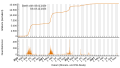
 COVID Confirmed Cases Central African Republic.png 2,000 × 1,500; 77 KB
-
-
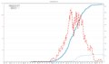
 COVID-19-Pandemie - CF (Zentralafrikanische Republik) - Tote (800px).svg 800 × 450; 460 KB
-
 WHO Covid 2020 Jan-Aug daily C Central African R.pdf 3,300 × 1,950; 22 KB
-
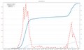 WHO Covid C Central African R.pdf 3,300 × 1,950; 18 KB
-
 WHO Covid rn confirmed,deaths African Region02.pdf 3,300 × 1,950; 29 KB

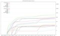
_-_Infizierte_(800px).svg)
_-_Tote_(800px).svg)