Category:Details of Stadhuis Klundert
Jump to navigation
Jump to search
| NO WIKIDATA ID FOUND! Search for Details of Stadhuis Klundert on Wikidata | |
| Upload media |
| Object location | | View all coordinates using: OpenStreetMap |
|---|
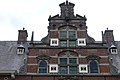
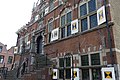
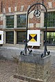
Nederlands: Afbeeldingen van het Stadhuis van Klundert, Stadhuisring 1, 4791 HS Klundert. Gelegen in Klundert, behorende tot de gemeente Moerdijk, in de provincie Noord-Brabant in het zuiden van Nederland
|
This is a category about rijksmonument number 23675
|
Media in category "Details of Stadhuis Klundert"
The following 31 files are in this category, out of 31 total.
-
 Detail Stadhuis Klundert P1170355.jpg 4,000 × 2,672; 5.33 MB
-
 Detail Stadhuis Klundert P1170357.jpg 2,672 × 4,000; 5.96 MB
-
 Detail Stadhuis Klundert P1170358 copy.jpg 2,322 × 1,551; 1,000 KB
-
 Detail Stadhuis Klundert P1170358 copy2.jpg 980 × 654; 238 KB
-
 Detail Stadhuis Klundert P1170358.jpg 4,000 × 2,672; 5.5 MB
-
 Detail Stadhuis Klundert P1170359 copy.jpg 2,349 × 1,569; 1,020 KB
-
 Detail Stadhuis Klundert P1170359.jpg 4,000 × 2,672; 6.03 MB
-
 Detail Stadhuis Klundert P1170360.jpg 4,000 × 2,672; 6 MB
-
 Detail Stadhuis Klundert P1170361 copy.jpg 1,859 × 1,241; 693 KB
-
 Detail Stadhuis Klundert P1170361 copy1.jpg 1,392 × 929; 435 KB
-
 Detail Stadhuis Klundert P1170362.jpg 2,672 × 4,000; 5.68 MB
-
 Detail Stadhuis Klundert P1170363.jpg 2,672 × 4,000; 5.59 MB
-
 Detail Stadhuis Klundert P1170364.jpg 4,000 × 2,672; 5.53 MB
-
 Detail Stadhuis Klundert P1170365.jpg 4,000 × 2,672; 5.59 MB
-
 Detail Stadhuis Klundert P1170366 copy.jpg 2,621 × 1,750; 1.26 MB
-
 Detail Stadhuis Klundert P1170366.jpg 4,000 × 2,672; 5.59 MB
-
 Detail Stadhuis Klundert P1170368 copy.jpg 2,305 × 3,450; 1.92 MB
-
 Detail Stadhuis Klundert P1170369.jpg 2,672 × 4,000; 6.01 MB
-
 Detail Stadhuis Klundert P1170488.jpg 2,672 × 4,000; 5.82 MB
-
 Detail Stadhuis Klundert P1170508.jpg 2,672 × 4,000; 5.68 MB
-
 Detail Stadhuis Klundert P1170515.jpg 4,000 × 2,672; 4.42 MB
-
 Detail Stadhuis Klundert P1170516.jpg 2,672 × 4,000; 4.1 MB
-
 Detail Stadhuis Klundert P1170594.jpg 2,672 × 4,000; 5.57 MB
-
 Detail Stadhuis Klundert P1170595 copy.jpg 2,263 × 1,512; 988 KB
-
 Detail Stadhuis Klundert P1170595.jpg 4,000 × 2,672; 5.44 MB
-
 Detail Stadhuis Klundert P1570397.jpg 4,000 × 2,672; 5.62 MB
-
 Detail Stadhuis Klundert P1570399.jpg 4,000 × 2,672; 5.95 MB
-
 Exterieur BORDES, DETAIL (NATUURSTEEN) - Klundert - 20274550 - RCE.jpg 788 × 1,200; 286 KB
-
 Exterieur BORDES, DETAIL (NATUURSTEEN) - Klundert - 20274551 - RCE.jpg 788 × 1,200; 272 KB
-
 Exterieur BORDES, DETAIL (NATUURSTEEN) - Klundert - 20274552 - RCE.jpg 1,200 × 788; 349 KB
-
 Kanonnen P1570392 copy.jpg 2,274 × 1,520; 1.09 MB


_-_Klundert_-_20274550_-_RCE.jpg)
_-_Klundert_-_20274551_-_RCE.jpg)
_-_Klundert_-_20274552_-_RCE.jpg)
