Category:Derrygarve, County Londonderry
Jump to navigation
Jump to search
English: Derrygarve is a townland of 863 acres in the Electoral Division of Castledawson, in Civil Parish of Artrea, in the Barony of Loughinsholin, in the County of Londonderry
Media in category "Derrygarve, County Londonderry"
The following 9 files are in this category, out of 9 total.
-
 Derrygarve - geograph.org.uk - 338863.jpg 640 × 286; 28 KB
-
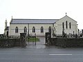 Derrygarve RC Church - geograph.org.uk - 338997.jpg 640 × 479; 36 KB
-
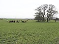
 Derrygarve Townland - geograph.org.uk - 338862.jpg 640 × 308; 47 KB
-
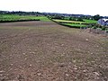
 Derrygarve Townland - geograph.org.uk - 338865.jpg 640 × 479; 57 KB
-
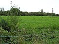
 Derrygarve Townland - geograph.org.uk - 338998.jpg 640 × 479; 45 KB
-
 Derrygarve Townland - geograph.org.uk - 569639.jpg 640 × 479; 73 KB
-
 Derrygarve Townland - geograph.org.uk - 569641.jpg 640 × 479; 72 KB
-
 New Bridge, Derrygarve - geograph.org.uk - 338859.jpg 640 × 285; 42 KB
-
 Road at Derrygarve - geograph.org.uk - 338853.jpg 640 × 302; 30 KB


