Category:Derecho tracks
Jump to navigation
Jump to search
Media in category "Derecho tracks"
The following 19 files are in this category, out of 19 total.
-
 1995jul12-13rpts.jpg 600 × 337; 36 KB
-
 2020aug-derecho-storm-crop-overlay-usda-map.png 705 × 545; 406 KB
-
 Corn Belt Derecho Path.png 765 × 424; 27 KB
-
 Derecho Path.png 624 × 479; 388 KB
-
 I-94 Derecho.jpg 600 × 347; 39 KB
-
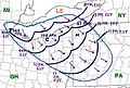
 July 4, 1977 Derecho.jpg 544 × 327; 29 KB
-
 July 7-8 Great Lakes Derecho.jpg 700 × 247; 29 KB
-
 July1995derechos.jpg 650 × 290; 34 KB
-
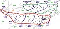
 June 12 and 13, 2013 Derecho Events.png 960 × 720; 324 KB
-
 May 30-31 1998 derecho.jpg 600 × 267; 36 KB
-
 Memphis Derecho.JPG 600 × 494; 40 KB
-
 National Weather Service (NWS) August 2020 Derecho Damage Survey Composite Map.png 1,804 × 1,204; 184 KB
-
 National Weather Service (NWS) Des Moines August 2020 Derecho Wind Estimate Map.jpg 1,392 × 863; 1.23 MB
-

-
 Ohio Fireworks Derecho.jpg 450 × 304; 34 KB
-
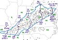
 Ontario-Adirondacks derecho July 14-15 1995.jpg 600 × 355; 33 KB
-
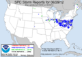 SPC Storm Reports 20120629.png 581 × 408; 14 KB
-
 Syracuse-Rochester Derecho.jpg 650 × 318; 39 KB
-
 West Virginia-Kentucky Derecho.jpg 480 × 329; 32 KB


_August_2020_Derecho_Damage_Survey_Composite_Map.png)
_Des_Moines_August_2020_Derecho_Wind_Estimate_Map.jpg)
_Quad_Cities_August_2020_Derecho_Localized_Wind_Estimate_Map.png)


