Category:Der verworrene Stein
Jump to navigation
Jump to search
| Object location | | View all coordinates using: OpenStreetMap |
|---|
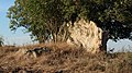
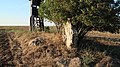
menhir near Hettstedt, Germany | |||||
| Upload media | |||||
| Instance of | |||||
|---|---|---|---|---|---|
| Location | Hettstedt, Mansfeld-Südharz, Saxony-Anhalt, Germany | ||||
| Heritage designation | |||||
 | |||||
Media in category "Der verworrene Stein"
The following 5 files are in this category, out of 5 total.
-
 Verworfener Stein bei Welfesholz.JPG 4,000 × 3,000; 839 KB
-
 Verwovener Stein bei Welfesholz 1.JPG 5,184 × 2,912; 9.64 MB
-
 Verwovener Stein bei Welfesholz 2.JPG 5,184 × 2,912; 9.79 MB
-
 Verwovener Stein bei Welfesholz 3.JPG 5,184 × 2,912; 9.31 MB
-
 Verwovener Stein bei Welfesholz 4.JPG 5,184 × 2,912; 9.49 MB


