Category:Denkmalzone Ortskern (Forst an der Weinstraße)
Jump to navigation
Jump to search
| Object location | | View all coordinates using: OpenStreetMap |
|---|

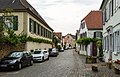
Monument zone village centre Weinstraße 24-118 (even nos.), 29-119 (odd nos.), Im Kirchenstück, Wassergasse
- Expansion of the linear settlement around 1850, rich uniformly grown wine village.
- wineries usually by the type of incomplete U-shaped farm, farm estates of the 17th to 19th century.
Media in category "Denkmalzone Ortskern (Forst an der Weinstraße)"
The following 14 files are in this category, out of 14 total.
-
 006 2015 07 07 Kulturdenkmaeler Forst.jpg 2,485 × 2,011; 3.31 MB
-
 007 2015 07 07 Kulturdenkmaeler Forst.jpg 2,811 × 1,778; 4.57 MB
-
 008 2015 07 07 Kulturdenkmaeler Forst.jpg 2,767 × 1,807; 3.55 MB
-
 009 2015 07 07 Kulturdenkmaeler Forst.jpg 2,693 × 1,856; 4.96 MB
-
 010 2015 06 16 Kulturdenkmaeler Forst.jpg 2,637 × 1,895; 5.05 MB
-
 011 2015 07 07 Kulturdenkmaeler Forst.jpg 2,793 × 1,790; 3.81 MB
-
 012 2015 06 16 Kulturdenkmaeler Forst.jpg 1,953 × 2,561; 4.03 MB
-
 014 2015 06 16 Kulturdenkmaeler Forst.jpg 2,644 × 1,890; 4.09 MB
-
 016 2015 04 10 Kulturdenkmaeler Forst.jpg 2,692 × 1,857; 3.77 MB
-
 018 2015 07 07 Kulturdenkmaeler Forst.jpg 2,565 × 1,948; 4.2 MB
-
 019 2015 07 07 Kulturdenkmaeler Forst.jpg 2,424 × 2,061; 4.6 MB
-
 020 2015 06 16 Kulturdenkmaeler Forst.jpg 2,561 × 1,951; 5.62 MB
-
 021 2015 07 07 Kulturdenkmaeler Forst.jpg 1,897 × 2,634; 5.12 MB
-
 022 2015 04 10 Kulturdenkmaeler Forst.jpg 2,851 × 1,753; 4.61 MB


