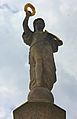
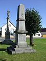
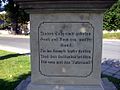
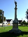
Category:Denkmal für die Gefallenen im Deutsch-Französischen Krieg (Stolzenhain an der Röder)
Jump to navigation
Jump to search
| Object location | | View all coordinates using: OpenStreetMap |
|---|
war memorial in Brandenburg, Germany  | |||||
| Upload media | |||||
| Instance of | |||||
|---|---|---|---|---|---|
| Commemorates | |||||
| Location | Röderland, Elbe-Elster District, Brandenburg, Germany | ||||
| Heritage designation | |||||
| Inception |
| ||||
 | |||||
This is the category of the Brandenburger Baudenkmal (cultural heritage monument) with the ID 09135705 (Wikidata)
|
Media in category "Denkmal für die Gefallenen im Deutsch-Französischen Krieg (Stolzenhain an der Röder)"
The following 19 files are in this category, out of 19 total.
-
 Nike Stolzenhain 2012 sb.jpg 2,001 × 3,100; 779 KB
-
 Nike Stolzenhain IMG 9804.jpg 2,838 × 3,397; 2.52 MB
-
 Stolzenhain 01.jpg 1,134 × 1,512; 1.51 MB
-
 Stolzenhain 03.jpg 1,134 × 850; 787 KB
-
 Stolzenhain 12.jpg 1,134 × 850; 762 KB
-
 Stolzenhain 13.jpg 567 × 425; 252 KB
-
 Stolzenhain 14.jpg 567 × 425; 269 KB
-
 Stolzenhain 15.jpg 850 × 638; 514 KB
-
 Stolzenhain 16.jpg 850 × 638; 496 KB
-
 Stolzenhain 18 b.jpg 663 × 1,091; 152 KB
-
 Stolzenhain 18.jpg 850 × 1,134; 755 KB
-
 Stolzenhain 2012 sa.jpg 5,184 × 3,456; 4.54 MB
-
 Stolzenhain 2012 sb.jpg 5,184 × 3,456; 3.29 MB
-
 Stolzenhain Roeder Denkmal.jpg 4,000 × 3,000; 1.08 MB
-
 Stolzenhain röder kriegerdenkmal 2019-07-12 (1).jpg 4,896 × 3,672; 5.4 MB
-
 Stolzenhain röder kriegerdenkmal 2019-07-12 (13).jpg 4,896 × 3,672; 4.22 MB
-
 Stolzenhain röder kriegerdenkmal 2019-07-12 (5).jpg 3,672 × 4,896; 3.26 MB
-
 Stolzenhain röder kriegerdenkmal 2019-07-12 (7).jpg 3,672 × 4,896; 3.97 MB
-
 Stolzenhain röder kriegerdenkmal 2019-07-12 (8).jpg 3,672 × 4,896; 4.22 MB


.jpg)
.jpg)
.jpg)
.jpg)
.jpg)