Category:Denford
Jump to navigation
Jump to search
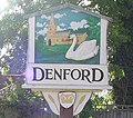
English: Denford is a small village and civil parish situated in East Northamptonshire, England. At the time of the 2001 census, the parish population was 250 people.
village and civil parish in East Northamptonshire, England in United Kingdom .jpg)  | |||||
| Upload media | |||||
| Instance of | |||||
|---|---|---|---|---|---|
| Location | North Northamptonshire, Northamptonshire, East Midlands, England | ||||
| Population |
| ||||
 | |||||
Subcategories
This category has the following 3 subcategories, out of 3 total.
H
- Holy Trinity Church, Denford (2 F)
I
- The Inn at Denford (2 F)
Media in category "Denford"
The following 98 files are in this category, out of 98 total.
-
 A14 near Thrapston - geograph.org.uk - 3819732.jpg 640 × 480; 272 KB
-
 A45 heading south - geograph.org.uk - 2995791.jpg 640 × 480; 56 KB
-
 A45 near Denford - geograph.org.uk - 4577851.jpg 4,608 × 3,456; 2.64 MB
-
 A45 southbound - geograph.org.uk - 5366752.jpg 640 × 480; 36 KB
-
 A45 southbound - geograph.org.uk - 5366754.jpg 640 × 480; 29 KB
-
 A45 southbound - geograph.org.uk - 5366761.jpg 640 × 480; 32 KB
-
 Alongside Denford Old Covert - geograph.org.uk - 6524764.jpg 1,024 × 768; 194 KB
-
 Axles and tyres - geograph.org.uk - 6524664.jpg 1,024 × 768; 233 KB
-
 Barley field and clump of trees - geograph.org.uk - 6524652.jpg 1,024 × 768; 201 KB
-
 Barley field and woodland, Denford Ash - geograph.org.uk - 6524758.jpg 1,024 × 768; 224 KB
-
 Barley field edge - geograph.org.uk - 6521830.jpg 1,024 × 768; 221 KB
-
 Barleyfield and Denford Ash - geograph.org.uk - 6524818.jpg 1,024 × 768; 184 KB
-
 Bean field and Denford Old Covert - geograph.org.uk - 6524803.jpg 1,024 × 768; 267 KB
-
 Bridleway along a dismantled railway - geograph.org.uk - 130464.jpg 640 × 480; 60 KB
-
 Bridleway alongside Vicarage Spinney - geograph.org.uk - 6524659.jpg 1,024 × 768; 349 KB
-
 Bridleway near Brigg's Lodge Farm - geograph.org.uk - 6521745.jpg 1,024 × 768; 316 KB
-
 Bridleway near Denford Ash Farm - geograph.org.uk - 6524657.jpg 1,024 × 768; 352 KB
-
 Bridleway near Vicarage Spinney - geograph.org.uk - 6524658.jpg 1,024 × 768; 268 KB
-

-
 Bridleway to Brigg's Lodge Farm - geograph.org.uk - 6521764.jpg 1,024 × 768; 288 KB
-
 Crop field near Denford - geograph.org.uk - 2995738.jpg 640 × 480; 89 KB
-
 Crop field near Thrapston - geograph.org.uk - 2995807.jpg 640 × 480; 72 KB
-
 Denford Ash Farm - geograph.org.uk - 6524814.jpg 1,024 × 732; 158 KB
-
 Denford Ash Water Tower - geograph.org.uk - 129907.jpg 480 × 640; 74 KB
-
 Denford Garage - geograph.org.uk - 2995740.jpg 640 × 480; 71 KB
-
 Denford Lock on the River Nene - geograph.org.uk - 1381821.jpg 640 × 480; 59 KB
-
 Denford Old Ash - geograph.org.uk - 6524808.jpg 1,024 × 768; 300 KB
-

-
 Denford view near river.jpg 3,264 × 2,448; 2.97 MB
-
 Denford water Tower.jpg 1,920 × 2,640; 2.58 MB
-
 Denford, Holy Trinity - geograph.org.uk - 6364906.jpg 3,456 × 4,608; 5.2 MB
-
 Eastbound A14 near Thrapston - geograph.org.uk - 3819740.jpg 640 × 480; 255 KB
-
 End of a farm track near Denford Old Covert - geograph.org.uk - 6521757.jpg 1,024 × 768; 178 KB
-
 Farm track near Denford - geograph.org.uk - 6524660.jpg 1,024 × 768; 244 KB
-
 Farmland near Denford - geograph.org.uk - 2995785.jpg 640 × 480; 78 KB
-
 Farmland near Denford North Lodge - geograph.org.uk - 2995798.jpg 640 × 480; 76 KB
-
 Field edge and plantation near Denford Ash Farm - geograph.org.uk - 6524855.jpg 1,024 × 768; 216 KB
-
 Field edge and Top Lodge - geograph.org.uk - 6524800.jpg 1,024 × 768; 249 KB
-
 Field edge and unnamed plantation - geograph.org.uk - 6524807.jpg 1,024 × 768; 165 KB
-
 Field edge near Denford - geograph.org.uk - 6524665.jpg 1,024 × 768; 230 KB
-
 Field of ripening barley - geograph.org.uk - 6524760.jpg 1,024 × 768; 186 KB
-
 Footpath alongside Denford Old Ash - geograph.org.uk - 6521759.jpg 1,024 × 768; 188 KB
-
 Footpath and Denford Old Covert - geograph.org.uk - 6524804.jpg 1,024 × 768; 277 KB
-
 Footpath from Raunds to Denford Ash - geograph.org.uk - 129911.jpg 640 × 480; 73 KB
-
 Footpath near Denford Ash Farm - geograph.org.uk - 6524810.jpg 1,024 × 768; 314 KB
-
 Footpath through a field of barley - geograph.org.uk - 6524761.jpg 1,024 × 768; 217 KB
-
 Footpath to Denford (geograph 4299924).jpg 640 × 480; 58 KB
-
 Footpath to Denford Ash - geograph.org.uk - 129898.jpg 640 × 480; 100 KB
-
 Footpath to Denford Ash Farm - geograph.org.uk - 6521754.jpg 1,024 × 768; 216 KB
-
 Footpath to Denford Ash Farm - geograph.org.uk - 6524755.jpg 1,024 × 768; 227 KB
-
 Footpath to Denford Ash Farm - geograph.org.uk - 6524767.jpg 1,024 × 768; 171 KB
-
 Footpath to Denford Ash Farm - geograph.org.uk - 6524769.jpg 1,024 × 768; 208 KB
-
 Footpath to Ringstead - geograph.org.uk - 2995734.jpg 640 × 480; 76 KB
-
 Footpath to Ringstead from Raunds - geograph.org.uk - 143546.jpg 640 × 480; 91 KB
-
 Grass field near Denford - geograph.org.uk - 6521851.jpg 1,024 × 768; 142 KB
-
 Grazing by the River Nene, Denford - geograph.org.uk - 2995753.jpg 640 × 480; 56 KB
-
 Green Lane near Denford Ash - geograph.org.uk - 373569.jpg 640 × 480; 102 KB
-
 Green Lane with Blackthorn blossom - geograph.org.uk - 373574.jpg 640 × 480; 110 KB
-
 Hedgerow near Thrapston - geograph.org.uk - 2995804.jpg 640 × 480; 94 KB
-
 Holy Trinity, Denford - geograph.org.uk - 4482650.jpg 1,024 × 704; 244 KB
-
 Lane heading east towards the A14 - geograph.org.uk - 2995788.jpg 640 × 480; 59 KB
-
 Layby on the A45, Thrapston - geograph.org.uk - 6212930.jpg 1,858 × 1,180; 1.24 MB
-
 Layby on the A45, Thrapston - geograph.org.uk - 6533570.jpg 1,892 × 1,238; 1.38 MB
-
 Layby on the A45, Thrapston - geograph.org.uk - 6627144.jpg 1,892 × 1,236; 1.28 MB
-

-
 Narrow grass field near Denford Ash Farm - geograph.org.uk - 6524812.jpg 1,024 × 768; 171 KB
-
 Overgrown hedge - geograph.org.uk - 6524562.jpg 1,024 × 768; 177 KB
-
 River Nene - geograph.org.uk - 4299904.jpg 640 × 480; 46 KB
-
 River Nene - geograph.org.uk - 4516534.jpg 480 × 640; 106 KB
-
 River Nene approaching Denford - geograph.org.uk - 130456.jpg 640 × 480; 86 KB
-
 River Nene north of Denford - geograph.org.uk - 130469.jpg 640 × 480; 67 KB
-
 River Nene north of Denford - geograph.org.uk - 2995756.jpg 640 × 480; 79 KB
-
 River Nene, Denford - geograph.org.uk - 2995751.jpg 640 × 480; 84 KB
-
 Roadway at Denford Ash Farm - geograph.org.uk - 6524816.jpg 1,024 × 768; 176 KB
-
 Roadway gate near Denford Ash Farm - geograph.org.uk - 6524857.jpg 1,024 × 768; 220 KB
-
 Roadway to Denford Ash Farm - geograph.org.uk - 6524670.jpg 1,024 × 768; 281 KB
-

-
 The Cock pub, Denford - geograph.org.uk - 4514227.jpg 4,320 × 3,240; 4.75 MB
-
 Top Lodge - geograph.org.uk - 2995810.jpg 640 × 480; 52 KB
-
 Track to Denford North Lodge - geograph.org.uk - 2995796.jpg 640 × 480; 59 KB
-
 Triangulation Pillar near Denford Ash - geograph.org.uk - 2341738.jpg 640 × 480; 151 KB
-
 UK Denford-2.jpg 836 × 741; 412 KB
-
 UK Denford.jpg 836 × 1,747; 330 KB
-
 Uncut grass field near Denford - geograph.org.uk - 6524666.jpg 1,024 × 768; 206 KB
-
 Water Tower near Briggs Lodge Farm - geograph.org.uk - 2341744.jpg 640 × 480; 91 KB
-
 Water tower near Denton - geograph.org.uk - 6524669.jpg 768 × 1,024; 228 KB
-
 Westbound A14 approaching Junction 12 - geograph.org.uk - 3819745.jpg 640 × 480; 246 KB
-
 Wheat field near Denford - geograph.org.uk - 6521848.jpg 1,024 × 768; 189 KB
-
 Wheat field near Denford Ash Farm - geograph.org.uk - 6524654.jpg 1,024 × 768; 190 KB
-
 Wheat field near Denford Ash Farm - geograph.org.uk - 6524655.jpg 1,024 × 768; 169 KB
-
 Wheat field near Denford Ash Farm - geograph.org.uk - 6524671.jpg 1,024 × 768; 212 KB
-
 Wheat field near Top Lodge - geograph.org.uk - 6521827.jpg 1,024 × 768; 243 KB
-
 Woodford Lock - geograph.org.uk - 2059159.jpg 640 × 480; 84 KB
-
 A quiet Backwater^ - geograph.org.uk - 356539.jpg 480 × 640; 87 KB
-
 Bridleway from Keyston to Denford - geograph.org.uk - 129901.jpg 640 × 480; 90 KB
-
 Farm Road at Ringstead - geograph.org.uk - 143548.jpg 640 × 480; 69 KB
-
 Field-edge Footpath - geograph.org.uk - 129880.jpg 640 × 476; 70 KB
-
 Over the A 14 - geograph.org.uk - 378193.jpg 640 × 480; 107 KB


