Category:Den Boerenstamppot
Jump to navigation
Jump to search
| Object location | | View all coordinates using: OpenStreetMap |
|---|
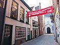
Nederlands: Afbeeldingen van de horeca-gelegenheid Den Boerenstamppot, Schoolstraat 3, 4811 WB Breda. Gelegen in Breda Centrum in Breda in de provincie Noord-Brabant in het zuiden van Nederland. Den Boerenstamppot ligt dicht bij de Havermarkt en de Vismarktstraat en de Reigerstraat
Subcategories
This category has only the following subcategory.
I
Media in category "Den Boerenstamppot"
The following 5 files are in this category, out of 5 total.
-
 Den Boerenstamppot DSCF4877.jpg 1,536 × 2,048; 1.56 MB
-
 Den Boerenstamppot DSCF4878.jpg 2,048 × 1,536; 1.41 MB
-
 Den Boerenstamppot DSCF4879.jpg 2,048 × 1,536; 1.52 MB
-
 Den Boerenstamppot DSCF4880.jpg 1,536 × 2,048; 1.5 MB
-
 P1030341Schoolstraat copy.jpg 2,448 × 3,264; 2.07 MB


