Category:Demographics of Landkreis Havelland
Jump to navigation
Jump to search
Districts of Brandenburg:
Urban districts (cities):
| Object location | | View all coordinates using: OpenStreetMap |
|---|
| NO WIKIDATA ID FOUND! Search for Demographics of Landkreis Havelland on Wikidata | |
| Upload media |
Subcategories
This category has the following 13 subcategories, out of 13 total.
- Demographics of Amt Friesack (9 F)
- Demographics of Amt Rhinow (9 F)
B
- Demographics of Brieselang (3 F)
D
F
- Demographics of Falkensee (4 F)
K
- Demographics of Ketzin/Havel (3 F)
M
- Demographics of Milower Land (3 F)
N
- Demographics of Nauen (4 F)
P
- Demographics of Premnitz (3 F)
R
- Demographics of Rathenow (5 F)
S
W
- Demographics of Wustermark (3 F)
Media in category "Demographics of Landkreis Havelland"
The following 4 files are in this category, out of 4 total.
-
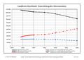 Altersstrukturentwicklung Landkreis Havelland.pdf 1,752 × 1,239; 98 KB
-
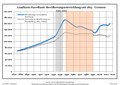 Bevölkerungsentwicklung Landkreis Havelland.pdf 1,752 × 1,239; 120 KB
-
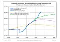 Bevölkerungsprognosen Landkreis Havelland.pdf 1,752 × 1,239; 67 KB
-
 Population pyramid of district Havelland (DE-2009-12-31).svg 530 × 615; 6 KB
.svg)