Category:Deadman Pass (Oregon)
Jump to navigation
Jump to search
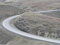
Cabbage Hill refers to the climb up to Deadman Pass on I-84. Westbound on I-84 is a 12.3 miles (19.8 km) Exit 226 on top of the hill to Oregon 331 at the bottom of the hill. The eastbound trip is 12.8 miles (20.6 km) rising form 1,390 feet (420 m) to 3,615 feet (1,102 m) at the Pass.
Media in category "Deadman Pass (Oregon)"
The following 20 files are in this category, out of 20 total.
-
 Cabbage Hill - Deadman Pass.jpg 2,048 × 2,048; 511 KB
-
 Elk graze on Cabbage Hill near I-84 (5662812972).jpg 2,048 × 1,536; 749 KB
-
 Highway84Eve.jpg 1,471 × 1,037; 248 KB
-
 I-84 at Deadman Pass View Point (53696231997).jpg 5,472 × 3,648; 2.02 MB
-
 I-84 at Deadman Pass View Point (53697124266).jpg 5,472 × 3,648; 1.99 MB
-
 I-84 at Deadman Pass View Point (53697124331).jpg 5,472 × 3,648; 2.8 MB
-
 I-84 at Deadman Pass View Point (53697331398).jpg 5,472 × 3,648; 2.24 MB
-
 I-84 at Deadman Pass View Point (53697331448).jpg 5,472 × 3,648; 2.04 MB
-
 I-84 at Deadman Pass View Point (53697465059).jpg 5,472 × 3,648; 2.01 MB
-
 I-84 at Deadman Pass View Point (53697465084).jpg 5,400 × 3,600; 2.33 MB
-
 Interstate 84 Between Blue Mountains and Pendleton, Oregon (265619268).jpg 1,280 × 960; 105 KB
-
 Interstate 84 Between Blue Mountains and Pendleton, Oregon (265619319).jpg 1,280 × 960; 108 KB
-
 Interstate 84 Between Blue Mountains and Pendleton, Oregon (265619373).jpg 1,280 × 960; 113 KB
-
 Interstate 84 Between Blue Mountains and Pendleton, Oregon (265619453).jpg 1,280 × 960; 119 KB
-
 Interstate 84 Between Blue Mountains and Pendleton, Oregon (265619496).jpg 1,280 × 960; 108 KB
-
 Interstate 84 Between Blue Mountains and Pendleton, Oregon (265619563).jpg 1,280 × 960; 110 KB
-
 Interstate 84 Between Blue Mountains and Pendleton, Oregon (265619613).jpg 1,280 × 960; 132 KB
-
 Interstate 84 Between Blue Mountains and Pendleton, Oregon (265619654).jpg 1,280 × 960; 114 KB
-
 W I-84 2174.jpg 4,608 × 3,072; 3.51 MB
-
 W I-84 2177.jpg 4,608 × 3,072; 3.71 MB

.jpg)

.jpg)
.jpg)
.jpg)
.jpg)
.jpg)
.jpg)
.jpg)
.jpg)
.jpg)
.jpg)
.jpg)
.jpg)
.jpg)
.jpg)
.jpg)

