Category:De Viaan
Jump to navigation
Jump to search
| Object location | | View all coordinates using: OpenStreetMap |
|---|
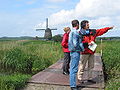
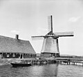
windmill in Alkmaar, Netherlands  | |||||
| Upload media | |||||
| Instance of |
| ||||
|---|---|---|---|---|---|
| Location | Alkmaar, North Holland, Netherlands | ||||
| Street address |
| ||||
| Located on street |
| ||||
| Has use |
| ||||
| Heritage designation |
| ||||
| Source of energy | |||||
 | |||||
|
This is a category about rijksmonument number 7163
|
| Address |
|
Media in category "De Viaan"
The following 22 files are in this category, out of 22 total.
-

-
 Alkmaar molen De Viaan.jpg 1,400 × 2,100; 1.74 MB
-
 Bergermeer1.jpg 2,272 × 1,704; 1.18 MB
-
 De Viaan.JPG 3,648 × 2,736; 1.68 MB
-

-

-

-

-

-

-
 Molen "De Viaan", van polder van de Bergermeer - Alkmaar - 20031476 - RCE.jpg 1,200 × 1,121; 251 KB
-
 Molen De Viaan - panoramio.jpg 2,736 × 3,648; 3.58 MB
-

-

-
 Molen, De Viaan - Alkmaar - 20031481 - RCE.jpg 1,200 × 1,180; 274 KB
-
 Molen, De Viaan, molenaarshuis - Alkmaar - 20031482 - RCE.jpg 1,200 × 1,183; 255 KB
-

-
 Viaanse Molen Alkmaar.jpg 1,024 × 746; 743 KB
-

-
 Windmill De Viaan in Alkmaar - The Netherlands.jpg 5,568 × 3,712; 7.45 MB
-
 Windmill De Viaan, Alkmaar, Noord-Holland.jpg 5,496 × 3,664; 7.05 MB
-


