Category:De Stille Hof (Hoogezand)
Jump to navigation
Jump to search
| Object location | | View all coordinates using: OpenStreetMap |
|---|
 | |||||
| Upload media | |||||
| Instance of | |||||
|---|---|---|---|---|---|
| Part of | |||||
| Location | Hoogezand, Midden-Groningen, Groningen, Netherlands | ||||
| Architect |
| ||||
| Heritage designation |
| ||||
| Inception |
| ||||
 | |||||
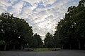
Nederlands: Begraafplaats De Stille Hof, Knijpslaan, Hoogezand
|
This is a category about rijksmonumentcomplex number 515869
|
Begraafplaats (1938, J. Vroom. jr.)
|
This is a category about rijksmonument number 515870
|
Poortgebouw (1938, M.J. Westerling)
|
This is a category about rijksmonument number 515871
|
| Address |
|
Media in category "De Stille Hof (Hoogezand)"
The following 3 files are in this category, out of 3 total.
-
 De Stille Hof - Knijpslaan 3.jpg 4,272 × 2,848; 2.27 MB
-
 Hoogezand - de Stille Hof Begr.plaats en ond - bij Knijpslaan 3.jpg 4,272 × 2,848; 2.59 MB
-
 Poortgebouw De Stille Hof Hoogezand.jpg 2,809 × 2,111; 1.27 MB

