Category:De Steur ('s-Hertogenbosch)
Jump to navigation
Jump to search
| Object location | | View all coordinates using: OpenStreetMap |
|---|
National Monument in the Netherlands  | |||||
| Upload media | |||||
| Instance of | |||||
|---|---|---|---|---|---|
| Location | 's-Hertogenbosch, North Brabant, Netherlands | ||||
| Street address |
| ||||
| Located on street | |||||
| Heritage designation |
| ||||
 | |||||
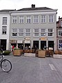
Nederlands: Huis De Steur, 's-Hertogenbosch
|
This is a category about rijksmonument number 21919
|
| Address |
|
Media in category "De Steur ('s-Hertogenbosch)"
The following 2 files are in this category, out of 2 total.
-
 's-Hertogenbosch Rijksmonument 21919 Visstraat 42, 44.JPG 2,736 × 3,648; 3.32 MB
-
 INTERIEUR, BESCHILDERDE PANELEN - 's-Hertogenbosch - 20263080 - RCE.jpg 1,200 × 771; 182 KB
