Category:De Put ('s-Hertogenbosch)
Jump to navigation
Jump to search
| Object location | | View all coordinates using: OpenStreetMap |
|---|
building in 's-Hertogenbosch, Netherlands  | |||||
| Upload media | |||||
| Instance of | |||||
|---|---|---|---|---|---|
| Location | 's-Hertogenbosch, North Brabant, Netherlands | ||||
| Street address |
| ||||
| Located on street | |||||
| Owned by |
| ||||
| Heritage designation |
| ||||
| Inception |
| ||||
 | |||||
Nederlands: Huis In Den Put
|
This is a category about rijksmonument number 21686
|
| Address |
|
Media in category "De Put ('s-Hertogenbosch)"
The following 6 files are in this category, out of 6 total.
-
 21686 Tweede Korenstraatje, De Put.jpg 2,112 × 2,816; 4.67 MB
-
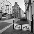
 Overzicht - 's-Hertogenbosch - 20110270 - RCE.jpg 1,816 × 2,652; 1.25 MB
-
 Tweede Korenstraatje, De Put.jpg 1,944 × 2,592; 2.1 MB
-
 Voorgevel - 's-Hertogenbosch - 20110271 - RCE.jpg 947 × 1,200; 209 KB
-
 Voorgevel - 's-Hertogenbosch - 20339295 - RCE.jpg 1,190 × 1,200; 281 KB
-
 Voorgevel, detail - 's-Hertogenbosch - 20339296 - RCE.jpg 1,190 × 1,200; 313 KB


