Category:De Pleats (Burgum)
Jump to navigation
Jump to search
| Object location | | View all coordinates using: OpenStreetMap |
|---|
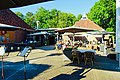
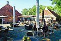
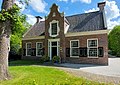
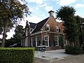
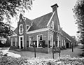
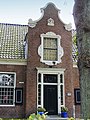
cultural centre in an old farmhouse in Burgum (Begrum), Friesland, Netherlands  | |||||
| Upload media | |||||
| Instance of | |||||
|---|---|---|---|---|---|
| Location | Burgum, Friesland, Netherlands | ||||
| Street address |
| ||||
| Located on street |
| ||||
| Heritage designation |
| ||||
| official website | |||||
 | |||||
|
This is a category about rijksmonument number 35637
|
| Address |
|
Media in category "De Pleats (Burgum)"
The following 8 files are in this category, out of 8 total.
-
 20210609 De Pleats1 Burgum.jpg 5,184 × 3,456; 4.66 MB
-
 20210609 De Pleats2 Burgum.jpg 5,184 × 3,456; 4.3 MB
-
 Aanzicht - Bergum - 20033813 - RCE.jpg 1,200 × 808; 294 KB
-
 Burgum, foarein fan De Pleats.jpg 2,836 × 2,020; 2.24 MB
-
 De Pleats Bergum..JPG 4,608 × 3,456; 1.71 MB
-
 De Pleats Burgum.jpg 2,767 × 2,004; 1.64 MB
-
-
 Voordeur van De Pleats Bergum.JPG 3,456 × 4,608; 1.74 MB


